Axien geodata
Axien (Saxony-Anhalt) is a populated place; located in Germany in Europe/Berlin (GMT+2) time zone. With population of 611 people, there are 8760 cities with bigger population in this country. Compared to other cities in Germany, 68.9% of cities are located further ↓South; 91.4% of cities are located further ←West and 72.4% of cities have higher elevation than Axien. Note1


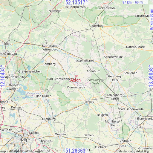
Axien GPS coordinates[2]
51° 42' 5.4" North, 12° 53' 14.82" East
| Map corner | latitude | longitude |
|---|---|---|
| Upper-left | 52.13517°, | 12.18433° |
| Center: | 51.7015°, | 12.88745° |
| Lower-right: | 51.26363°, | 13.59058° |
| Map W x H: | 96.9×96.9 km | = 60.2×60.2mi |
| max Lat: | 55.01917° ⇑31.1% North |
| Axien: | 51.7015° |
| min Lat: | ⇓68.9% South 47.40724° |
| min Long | Axien | max Long |
| 5.92978° | 12.88745° | 14.98853° |
| W 91.4%⇐ | ⇒8.6% E |
Elevation
Elevation of Axien is 75 m = 246 ft, and this is 174.1 m = 571 ft below average elevation for this country.
| Max E: |
1256 m = 4121 ft | 72.4% |
| Avg. | 249.1 m = 817 ft | |
| Axien | 75 m = 246 ft | |
Min E: |
-5 m = -16 ft | 27.6% |
See also: Germany elevation on elevation.city.
Geographical zone
Axien is located in North temperate zone (between Tropic of Cancer and the Arctic Circle). Distance of this North polar circle is 1652.5 km =1026.8 mi to North.| Distance of | km | miles | from Axien |
|---|---|---|---|
| North Pole | 4258.4 | 2646 | to North |
| Arctic Circle | 1652.5 | 1026.8 | to North |
| Tropic Cancer | 3142.7 | 1952.8 | to South |
| Equator | 5748.7 | 3572.1 | to South |


Nearby cities:
15 places around Axien: (largest is in red/bold)
• Annaburg
11.6 km =7.2 mi,  72°
72°
• Bad Schmiedeberg
10.7 km =6.6 mi,  260°
260°
• Dommitzsch
6.8 km =4.2 mi,  184°
184°
• Elsnig
10.5 km =6.5 mi,  164°
164°
• Elster
14.9 km =9.3 mi,  343°
343°
• Jessen
11.3 km =7 mi,  25°
25°
• Klöden
7.7 km =4.8 mi,  330°
330°
• Kossa
17 km =10.6 mi,  236°
236°
• Meuro
13.6 km =8.5 mi,  281°
281°
• Prettin
5.2 km =3.2 mi,  151°
151°
• Pretzsch
5.8 km =3.6 mi, 284°
• Torgau
17.4 km =10.8 mi, 154°
• Trossin
10.6 km =6.6 mi,  207°
207°
• Wartenburg
14.1 km =8.8 mi, 328°
• Zinna
15.5 km =9.6 mi, 162°
Sources, notices
• [Note1] Compared only with cities in Germany existing in our database
• [Src1] Map data: © OpenStreetMap contributors (CC-BY-SA)
• [Src2] Other city data from geonames.org with taken over terms of usage.
• [Src3] Geographical zone / Annual Mean Temperature by Robert A. Rohde @ Wikipedia
