Falkenberg geodata
Falkenberg (Brandenburg) is a populated place; located in Germany in Europe/Berlin (GMT+2) time zone. With population of 7,830 people, there are 1984 cities with bigger population in this country. Compared to other cities in Germany, 67.4% of cities are located further ↓South; 94% of cities are located further ←West and 70.5% of cities have higher elevation than Falkenberg. Note1
Administrative division(s):
- Level 1: Brandenburg
- Level 3: Landkreis Elbe-Elster
- Level 4: Falkenberg/Elster


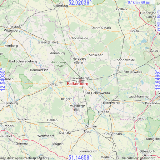
Falkenberg GPS coordinates[2]
51° 35' 8.052" North, 13° 14' 36.492" East
| Map corner | latitude | longitude |
|---|---|---|
| Upper-left | 52.02036°, | 12.54035° |
| Center: | 51.58557°, | 13.24347° |
| Lower-right: | 51.14658°, | 13.9466° |
| Map W x H: | 97.2×97.2 km | = 60.4×60.4mi |
| max Lat: | 55.01917° ⇑32.6% North |
| Falkenberg: | 51.58557° |
| min Lat: | ⇓67.4% South 47.40724° |
| min Long | Falkenberg | max Long |
| 5.92978° | 13.24347° | 14.98853° |
| W 94%⇐ | ⇒6% E |
Elevation
Elevation of Falkenberg is 88 m = 289 ft, and this is 161.1 m = 529 ft below average elevation for this country.
| Max E: |
1256 m = 4121 ft | 70.5% |
| Avg. | 249.1 m = 817 ft | |
| Falkenberg | 88 m = 289 ft | |
Min E: |
-5 m = -16 ft | 29.5% |
See also: Germany elevation on elevation.city.
Geographical zone
Falkenberg is located in North temperate zone (between Tropic of Cancer and the Arctic Circle). Distance of this North polar circle is 1665.4 km =1034.8 mi to North.| Distance of | km | miles | from Falkenberg |
|---|---|---|---|
| North Pole | 4271.3 | 2654.1 | to North |
| Arctic Circle | 1665.4 | 1034.8 | to North |
| Tropic Cancer | 3129.9 | 1944.8 | to South |
| Equator | 5735.8 | 3564.1 | to South |


Nearby cities:
15 places around Falkenberg: (largest is in red/bold)
• Annaburg
21.3 km =13.2 mi,  320°
320°
• Arzberg
10.3 km =6.4 mi,  232°
232°
• Bad Liebenwerda
12.9 km =8 mi,  125°
125°
• Beilrode
12.4 km =7.7 mi,  260°
260°
• Belgern
14.1 km =8.8 mi,  215°
215°
• Herzberg
11.4 km =7.1 mi,  351°
351°
• Mühlberg
16.9 km =10.5 mi,  185°
185°
• Nauwalde
21.9 km =13.6 mi,  148°
148°
• Schilda
9.8 km =6.1 mi,  80°
80°
• Schlieben
18.1 km =11.2 mi,  32°
32°
• Schönborn
17.1 km =10.6 mi, 84°
• Torgau
17.3 km =10.7 mi, 260°
• Tröbitz
13.2 km =8.2 mi, 83°
• Uebigau
4 km =2.5 mi, 76°
• Zinna
20.1 km =12.5 mi, 264°
Sources, notices
• [Note1] Compared only with cities in Germany existing in our database
• [Src1] Map data: © OpenStreetMap contributors (CC-BY-SA)
• [Src2] Other city data from geonames.org with taken over terms of usage.
• [Src3] Geographical zone / Annual Mean Temperature by Robert A. Rohde @ Wikipedia
