Lunden geodata
Lunden (Schleswig-Holstein) is a seat of a fourth-order administrative division; located in Germany in Europe/Berlin (GMT+2) time zone. With population of 1,652 people, there are 5599 cities with bigger population in this country. Compared to other cities in Germany, 96.6% of cities are located further ↓South; 65.1% of cities are located further →East and 97% of cities have higher elevation than Lunden. Note1


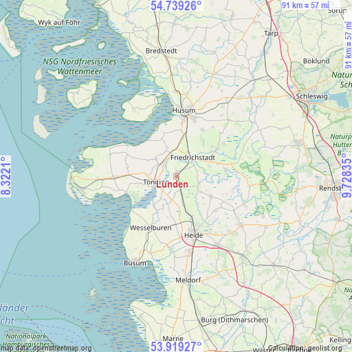
Lunden GPS coordinates[2]
54° 19' 52.716" North, 9° 1' 30.828" East
| Map corner | latitude | longitude |
|---|---|---|
| Upper-left | 54.73926°, | 8.3221° |
| Center: | 54.33131°, | 9.02523° |
| Lower-right: | 53.91927°, | 9.72835° |
| Map W x H: | 91.2×91.2 km | = 56.7×56.7mi |
| max Lat: | 55.01917° ⇑3.4% North |
| Lunden: | 54.33131° |
| min Lat: | ⇓96.6% South 47.40724° |
| min Long | Lunden | max Long |
| 5.92978° | 9.02523° | 14.98853° |
| W 34.9%⇐ | ⇒65.1% E |
Elevation
Elevation of Lunden is 4 m = 13 ft, and this is 245.1 m = 804 ft below average elevation for this country.
| Max E: |
1256 m = 4121 ft | 97% |
| Avg. | 249.1 m = 817 ft | |
| Lunden | 4 m = 13 ft | |
Min E: |
-5 m = -16 ft | 3% |
See also: Germany elevation on elevation.city.
Geographical zone
Lunden is located in North temperate zone (between Tropic of Cancer and the Arctic Circle). Distance of this North polar circle is 1360.1 km =845.1 mi to North.| Distance of | km | miles | from Lunden |
|---|---|---|---|
| North Pole | 3966 | 2464.4 | to North |
| Arctic Circle | 1360.1 | 845.1 | to North |
| Tropic Cancer | 3435.2 | 2134.5 | to South |
| Equator | 6041.1 | 3753.8 | to South |


Nearby cities:
15 places around Lunden: (largest is in red/bold)
• Friedrichstadt
6.3 km =3.9 mi,  38°
38°
• Groven
4.4 km =2.7 mi,  217°
217°
• Hemme
5.4 km =3.4 mi,  185°
185°
• Karolinenkoog
6.5 km =4 mi, 215°
• Kleve
7.6 km =4.7 mi,  122°
122°
• Koldenbüttel
6.4 km =4 mi,  24°
24°
• Kotzenbüll
7.8 km =4.8 mi,  271°
271°
• Krempel
1.7 km =1.1 mi,  162°
162°
• Lehe
1.1 km =0.7 mi,  355°
355°
• Oldenswort
7.2 km =4.5 mi,  309°
309°
• Rehm-Flehde-Bargen
5.4 km =3.4 mi, 185°
• Sankt Annen
3.9 km =2.4 mi,  64°
64°
• Schlichting
4.8 km =3 mi, 118°
• Stelle-Wittenwurth
7.4 km =4.6 mi,  167°
167°
• Tönning
5.6 km =3.5 mi,  255°
255°
Sources, notices
• [Note1] Compared only with cities in Germany existing in our database
• [Src1] Map data: © OpenStreetMap contributors (CC-BY-SA)
• [Src2] Other city data from geonames.org with taken over terms of usage.
• [Src3] Geographical zone / Annual Mean Temperature by Robert A. Rohde @ Wikipedia
