Leuna geodata
Leuna (Saxony-Anhalt) is a populated place; located in Germany in Europe/Berlin (GMT+2) time zone. With population of 6,929 people, there are 2201 cities with bigger population in this country. Compared to other cities in Germany, 63.6% of cities are located further ↓South; 82% of cities are located further ←West and 67.4% of cities have higher elevation than Leuna. Note1


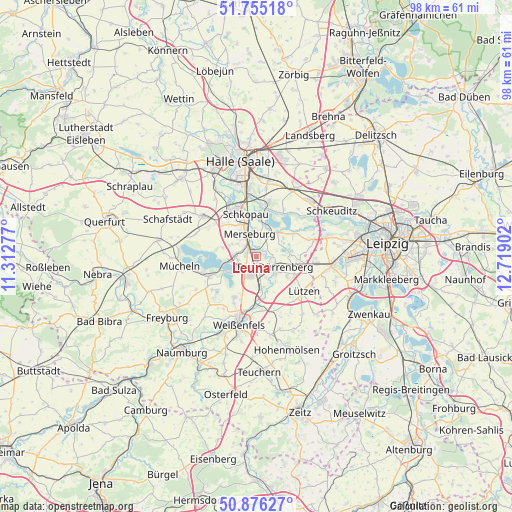
Leuna GPS coordinates[2]
51° 19' 4.188" North, 12° 0' 57.204" East
| Map corner | latitude | longitude |
|---|---|---|
| Upper-left | 51.75518°, | 11.31277° |
| Center: | 51.31783°, | 12.01589° |
| Lower-right: | 50.87627°, | 12.71902° |
| Map W x H: | 97.7×97.7 km | = 60.7×60.7mi |
| max Lat: | 55.01917° ⇑36.4% North |
| Leuna: | 51.31783° |
| min Lat: | ⇓63.6% South 47.40724° |
| min Long | Leuna | max Long |
| 5.92978° | 12.01589° | 14.98853° |
| W 82%⇐ | ⇒18% E |
Elevation
Elevation of Leuna is 105 m = 344 ft, and this is 144.1 m = 473 ft below average elevation for this country.
| Max E: |
1256 m = 4121 ft | 67.4% |
| Avg. | 249.1 m = 817 ft | |
| Leuna | 105 m = 344 ft | |
Min E: |
-5 m = -16 ft | 32.6% |
See also: Germany elevation on elevation.city.
Geographical zone
Leuna is located in North temperate zone (between Tropic of Cancer and the Arctic Circle). Distance of this North polar circle is 1695.2 km =1053.3 mi to North.| Distance of | km | miles | from Leuna |
|---|---|---|---|
| North Pole | 4301.1 | 2672.6 | to North |
| Arctic Circle | 1695.2 | 1053.3 | to North |
| Tropic Cancer | 3100.1 | 1926.3 | to South |
| Equator | 5706 | 3545.5 | to South |


Nearby cities:
15 places around Leuna: (largest is in red/bold)
• Bad Dürrenberg
4.3 km =2.7 mi,  125°
125°
• Beuna
4.6 km =2.9 mi,  268°
268°
• Frankleben
6.1 km =3.8 mi,  263°
263°
• Geusa
5.5 km =3.4 mi,  295°
295°
• Großkayna
6.5 km =4 mi,  242°
242°
• Großkorbetha
6.5 km =4 mi,  171°
171°
• Kötzschau
8 km =5 mi,  94°
94°
• Merseburg
4.5 km =2.8 mi,  335°
335°
• Ostrau
3 km =1.9 mi,  109°
109°
• Spergau
2.8 km =1.7 mi, 169°
• Tollwitz
6.7 km =4.2 mi,  122°
122°
• Wallendorf
6.2 km =3.9 mi,  41°
41°
• Wengelsdorf
4.5 km =2.8 mi,  155°
155°
• Zscherben
3.8 km =2.4 mi, 301°
• Zöschen
8.3 km =5.2 mi,  57°
57°
Sources, notices
• [Note1] Compared only with cities in Germany existing in our database
• [Src1] Map data: © OpenStreetMap contributors (CC-BY-SA)
• [Src2] Other city data from geonames.org with taken over terms of usage.
• [Src3] Geographical zone / Annual Mean Temperature by Robert A. Rohde @ Wikipedia
