Tiefenbach geodata
Tiefenbach (Bavaria) is a seat of a fourth-order administrative division; located in Germany in Europe/Berlin (GMT+2) time zone. In our database, there are 11009 cities with bigger population. Compared to other cities in Germany, 87.5% of cities are located further ↑North; 95.1% of cities are located further ←West and 71.3% of cities have lower elevation than Tiefenbach. Note1
Administrative division(s):
- Level 1: Bavaria
- Level 2: Lower Bavaria
- Level 3: Landkreis Passau
- Level 4: Tiefenbach


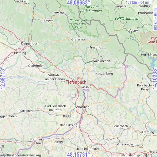
Tiefenbach GPS coordinates[2]
48° 37' 27.156" North, 13° 24' 0.9" East
| Map corner | latitude | longitude |
|---|---|---|
| Upper-left | 49.08683°, | 12.69713° |
| Center: | 48.62421°, | 13.40025° |
| Lower-right: | 48.15731°, | 14.10338° |
| Map W x H: | 103.4×103.4 km | = 64.2×64.2mi |
| max Lat: | 55.01917° ⇑87.5% North |
| Tiefenbach: | 48.62421° |
| min Lat: | ⇓12.5% South 47.40724° |
| min Long | Tiefenbach | max Long |
| 5.92978° | 13.40025° | 14.98853° |
| W 95.1%⇐ | ⇒4.9% E |
Elevation
Elevation of Tiefenbach is 368 m = 1207 ft, and this is 118.9 m = 390 ft above average elevation for this country.
| Max E: |
1256 m = 4121 ft | 28.7% |
| Tiefenbach | 368 m 1207 ft | |
| Avg. | 249.1 m = 817 ft | |
Min E: |
-5 m = -16 ft | 71.3% |
See also: Germany elevation on elevation.city.
Geographical zone
Tiefenbach is located in North temperate zone (between Tropic of Cancer and the Arctic Circle). Distance of this North polar circle is 1994.7 km =1239.4 mi to North.| Distance of | km | miles | from Tiefenbach |
|---|---|---|---|
| North Pole | 4600.6 | 2858.7 | to North |
| Arctic Circle | 1994.7 | 1239.4 | to North |
| Tropic Cancer | 2800.6 | 1740.2 | to South |
| Equator | 5406.5 | 3359.4 | to South |


Nearby cities:
15 places around Tiefenbach: (largest is in red/bold)
• Aicha vorm Wald
9.6 km =6 mi,  306°
306°
• Büchlberg
10.3 km =6.4 mi,  59°
59°
• Fürsteneck
11.4 km =7.1 mi,  25°
25°
• Fürstenstein
11.4 km =7.1 mi,  334°
334°
• Fürstenzell
12.9 km =8 mi,  208°
208°
• Haselbach
2.5 km =1.6 mi,  341°
341°
• Hutthurm
7.5 km =4.7 mi,  44°
44°
• Neukirchen vorm Wald
6.7 km =4.2 mi,  349°
349°
• Passau
6.8 km =4.2 mi,  160°
160°
• Ruderting
3.1 km =1.9 mi,  22°
22°
• Salzweg
6.2 km =3.9 mi,  97°
97°
• Thyrnau
9.8 km =6.1 mi,  94°
94°
• Tittling
11.4 km =7.1 mi, 353°
• Witzmannsberg
6.9 km =4.3 mi, 91°
• Witzmannsberg
10.4 km =6.5 mi,  6°
6°
Sources, notices
• [Note1] Compared only with cities in Germany existing in our database
• [Src1] Map data: © OpenStreetMap contributors (CC-BY-SA)
• [Src2] Other city data from geonames.org with taken over terms of usage.
• [Src3] Geographical zone / Annual Mean Temperature by Robert A. Rohde @ Wikipedia
