Aicha vorm Wald geodata
Aicha vorm Wald (Bavaria) is a seat of a fourth-order administrative division; located in Germany in Europe/Berlin (GMT+2) time zone. In our database, there are 11009 cities with bigger population. Compared to other cities in Germany, 86.8% of cities are located further ↑North; 94.3% of cities are located further ←West and 71.7% of cities have lower elevation than Aicha vorm Wald. Note1
Administrative division(s):
- Level 1: Bavaria
- Level 2: Lower Bavaria
- Level 3: Landkreis Passau
- Level 4: Aicha vorm Wald


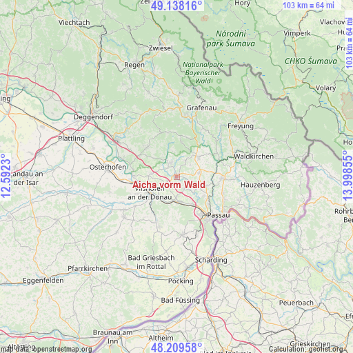
Aicha vorm Wald GPS coordinates[2]
48° 40' 33.636" North, 13° 17' 43.512" East
| Map corner | latitude | longitude |
|---|---|---|
| Upper-left | 49.13816°, | 12.5923° |
| Center: | 48.67601°, | 13.29542° |
| Lower-right: | 48.20958°, | 13.99855° |
| Map W x H: | 103.2×103.2 km | = 64.1×64.1mi |
| max Lat: | 55.01917° ⇑86.8% North |
| Aicha vorm Wald: | 48.67601° |
| min Lat: | ⇓13.2% South 47.40724° |
| min Long | Aicha vorm Wald | max Long |
| 5.92978° | 13.29542° | 14.98853° |
| W 94.3%⇐ | ⇒5.7% E |
Elevation
Elevation of Aicha vorm Wald is 372 m = 1220 ft, and this is 122.9 m = 403 ft above average elevation for this country.
| Max E: |
1256 m = 4121 ft | 28.3% |
| Aicha vorm Wald | 372 m 1220 ft | |
| Avg. | 249.1 m = 817 ft | |
Min E: |
-5 m = -16 ft | 71.7% |
See also: Germany elevation on elevation.city.
Geographical zone
Aicha vorm Wald is located in North temperate zone (between Tropic of Cancer and the Arctic Circle). Distance of this North polar circle is 1988.9 km =1235.8 mi to North.| Distance of | km | miles | from Aicha vorm Wald |
|---|---|---|---|
| North Pole | 4594.8 | 2855.1 | to North |
| Arctic Circle | 1988.9 | 1235.8 | to North |
| Tropic Cancer | 2806.3 | 1743.8 | to South |
| Equator | 5412.3 | 3363 | to South |


Nearby cities:
15 places around Aicha vorm Wald: (largest is in red/bold)
• Außernzell
8.6 km =5.3 mi,  308°
308°
• Fürstenstein
5.3 km =3.3 mi,  31°
31°
• Haselbach
7.7 km =4.8 mi,  116°
116°
• Hofkirchen
12.9 km =8 mi,  271°
271°
• Hutthurm
12.9 km =8 mi,  91°
91°
• Iggensbach
12.7 km =7.9 mi,  298°
298°
• Neukirchen vorm Wald
6.5 km =4 mi,  82°
82°
• Ruderting
9.4 km =5.8 mi,  107°
107°
• Saldenburg
11.7 km =7.3 mi,  22°
22°
• Schöllnach
12.2 km =7.6 mi,  315°
315°
• Thurmansbang
10.1 km =6.3 mi,  8°
8°
• Tiefenbach
9.6 km =6 mi,  126°
126°
• Tittling
8.5 km =5.3 mi,  48°
48°
• Vilshofen
9.3 km =5.8 mi,  234°
234°
• Witzmannsberg
10 km =6.2 mi,  63°
63°
Sources, notices
• [Note1] Compared only with cities in Germany existing in our database
• [Src1] Map data: © OpenStreetMap contributors (CC-BY-SA)
• [Src2] Other city data from geonames.org with taken over terms of usage.
• [Src3] Geographical zone / Annual Mean Temperature by Robert A. Rohde @ Wikipedia
