Fürstenzell geodata
Fürstenzell (Bavaria) is a populated place; located in Germany in Europe/Berlin (GMT+2) time zone. With population of 7,719 people, there are 2003 cities with bigger population in this country. Compared to other cities in Germany, 88.9% of cities are located further ↑North; 94.5% of cities are located further ←West and 70.6% of cities have lower elevation than Fürstenzell. Note1
Administrative division(s):
- Level 1: Bavaria
- Level 2: Lower Bavaria
- Level 3: Landkreis Passau
- Level 4: Fürstenzell, Markt


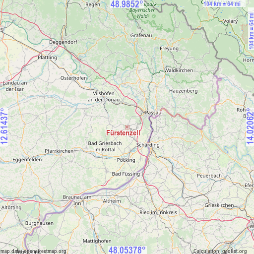
Fürstenzell GPS coordinates[2]
48° 31' 17.868" North, 13° 19' 2.964" East
| Map corner | latitude | longitude |
|---|---|---|
| Upper-left | 48.9852°, | 12.61437° |
| Center: | 48.52163°, | 13.31749° |
| Lower-right: | 48.05378°, | 14.02062° |
| Map W x H: | 103.6×103.6 km | = 64.4×64.4mi |
| max Lat: | 55.01917° ⇑88.9% North |
| Fürstenzell: | 48.52163° |
| min Lat: | ⇓11.1% South 47.40724° |
| min Long | Fürstenzell | max Long |
| 5.92978° | 13.31749° | 14.98853° |
| W 94.5%⇐ | ⇒5.5% E |
Elevation
Elevation of Fürstenzell is 363 m = 1191 ft, and this is 113.9 m = 374 ft above average elevation for this country.
| Max E: |
1256 m = 4121 ft | 29.4% |
| Fürstenzell | 363 m 1191 ft | |
| Avg. | 249.1 m = 817 ft | |
Min E: |
-5 m = -16 ft | 70.6% |
See also: Germany elevation on elevation.city.
Geographical zone
Fürstenzell is located in North temperate zone (between Tropic of Cancer and the Arctic Circle). Distance of this North polar circle is 2006.1 km =1246.5 mi to North.| Distance of | km | miles | from Fürstenzell |
|---|---|---|---|
| North Pole | 4612 | 2865.8 | to North |
| Arctic Circle | 2006.1 | 1246.5 | to North |
| Tropic Cancer | 2789.2 | 1733.1 | to South |
| Equator | 5395.1 | 3352.4 | to South |


Nearby cities:
15 places around Fürstenzell: (largest is in red/bold)
• Bad Griesbach
12 km =7.5 mi,  229°
229°
• Beutelsbach
15.1 km =9.4 mi,  282°
282°
• Haarbach
12.6 km =7.8 mi,  258°
258°
• Haselbach
14.8 km =9.2 mi,  21°
21°
• Neuburg
9.7 km =6 mi,  99°
99°
• Neuhaus am Inn
10.2 km =6.3 mi,  131°
131°
• Ortenburg
7.5 km =4.7 mi,  291°
291°
• Passau
9.7 km =6 mi,  59°
59°
• Pocking
13.4 km =8.3 mi,  181°
181°
• Reut
16.3 km =10.1 mi,  298°
298°
• Ruderting
16 km =9.9 mi,  27°
27°
• Salzweg
16.1 km =10 mi,  49°
49°
• Tettenweis
9.4 km =5.8 mi,  201°
201°
• Tiefenbach
12.9 km =8 mi, 28°
• Vilshofen
14.9 km =9.3 mi,  321°
321°
Sources, notices
• [Note1] Compared only with cities in Germany existing in our database
• [Src1] Map data: © OpenStreetMap contributors (CC-BY-SA)
• [Src2] Other city data from geonames.org with taken over terms of usage.
• [Src3] Geographical zone / Annual Mean Temperature by Robert A. Rohde @ Wikipedia
