Passau geodata
Passau (Bavaria) is a seat of a third-order administrative division; located in Germany in Europe/Berlin (GMT+2) time zone. With population of 50,560 people, there are 221 cities with bigger population in this country. Compared to other cities in Germany, 88.3% of cities are located further ↑North; 95.3% of cities are located further ←West and 71% of cities have lower elevation than Passau. Note1
Administrative division(s):
- Level 1: Bavaria
- Level 2: Lower Bavaria
- Level 3: Kreisfreie Stadt Passau
- Level 4: Passau


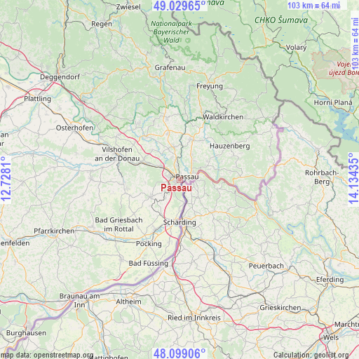
Passau GPS coordinates[2]
48° 33' 59.4" North, 13° 25' 52.392" East
| Map corner | latitude | longitude |
|---|---|---|
| Upper-left | 49.02965°, | 12.7281° |
| Center: | 48.5665°, | 13.43122° |
| Lower-right: | 48.09906°, | 14.13435° |
| Map W x H: | 103.5×103.5 km | = 64.3×64.3mi |
| max Lat: | 55.01917° ⇑88.3% North |
| Passau: | 48.5665° |
| min Lat: | ⇓11.7% South 47.40724° |
| min Long | Passau | max Long |
| 5.92978° | 13.43122° | 14.98853° |
| W 95.3%⇐ | ⇒4.7% E |
Elevation
Elevation of Passau is 366 m = 1201 ft, and this is 116.9 m = 384 ft above average elevation for this country.
| Max E: |
1256 m = 4121 ft | 29% |
| Passau | 366 m 1201 ft | |
| Avg. | 249.1 m = 817 ft | |
Min E: |
-5 m = -16 ft | 71% |
See also: Passau elevation on elevation.city.
Geographical zone
Passau is located in North temperate zone (between Tropic of Cancer and the Arctic Circle). Distance of this North polar circle is 2001.1 km =1243.4 mi to North.| Distance of | km | miles | from Passau |
|---|---|---|---|
| North Pole | 4607 | 2862.7 | to North |
| Arctic Circle | 2001.1 | 1243.4 | to North |
| Tropic Cancer | 2794.2 | 1736.2 | to South |
| Equator | 5400.1 | 3355.5 | to South |


Nearby cities:
15 places around Passau: (largest is in red/bold)
• Aicha vorm Wald
15.7 km =9.8 mi,  320°
320°
• Büchlberg
13.4 km =8.3 mi,  29°
29°
• Fürstenzell
9.7 km =6 mi,  239°
239°
• Haselbach
9.3 km =5.8 mi,  340°
340°
• Hutthurm
12.2 km =7.6 mi,  14°
14°
• Neuburg
6.8 km =4.2 mi,  170°
170°
• Neuhaus am Inn
11.8 km =7.3 mi,  183°
183°
• Neukirchen vorm Wald
13.5 km =8.4 mi, 344°
• Obernzell
15.2 km =9.4 mi,  94°
94°
• Ortenburg
15.5 km =9.6 mi,  261°
261°
• Ruderting
9.3 km =5.8 mi,  353°
353°
• Salzweg
6.8 km =4.2 mi, 34°
• Thyrnau
9.4 km =5.8 mi,  53°
53°
• Tiefenbach
6.8 km =4.2 mi, 340°
• Witzmannsberg
7.7 km =4.8 mi,  36°
36°
Sources, notices
• [Note1] Compared only with cities in Germany existing in our database
• [Src1] Map data: © OpenStreetMap contributors (CC-BY-SA)
• [Src2] Other city data from geonames.org with taken over terms of usage.
• [Src3] Geographical zone / Annual Mean Temperature by Robert A. Rohde @ Wikipedia
