Veitshöchheim geodata
Veitshöchheim (Bavaria) is a seat of a fourth-order administrative division; located in Germany in Europe/Berlin (GMT+2) time zone. With population of 10,279 people, there are 1592 cities with bigger population in this country. Compared to other cities in Germany, 68.2% of cities are located further ↑North; 51.8% of cities are located further →East and 51.5% of cities have higher elevation than Veitshöchheim. Note1
Administrative division(s):
- Level 1: Bavaria
- Level 2: Regierungsbezirk Unterfranken
- Level 3: Landkreis Würzburg
- Level 4: Veitshöchheim


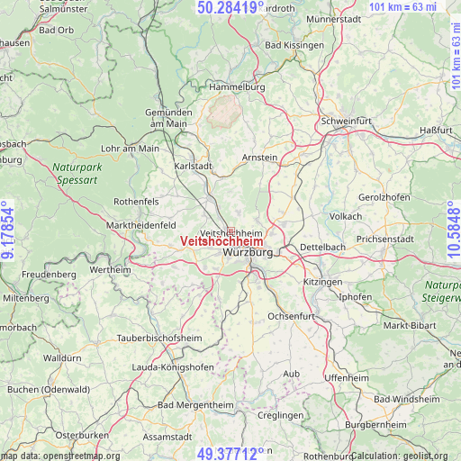
Veitshöchheim GPS coordinates[2]
49° 49' 58.008" North, 9° 52' 54.012" East
| Map corner | latitude | longitude |
|---|---|---|
| Upper-left | 50.28419°, | 9.17854° |
| Center: | 49.83278°, | 9.88167° |
| Lower-right: | 49.37712°, | 10.5848° |
| Map W x H: | 100.9×100.9 km | = 62.7×62.7mi |
| max Lat: | 55.01917° ⇑68.2% North |
| Veitshöchheim: | 49.83278° |
| min Lat: | ⇓31.8% South 47.40724° |
| min Long | Veitshöchheim | max Long |
| 5.92978° | 9.88167° | 14.98853° |
| W 48.2%⇐ | ⇒51.8% E |
Elevation
Elevation of Veitshöchheim is 215 m = 705 ft, and this is 34.1 m = 112 ft below average elevation for this country.
| Max E: |
1256 m = 4121 ft | 51.5% |
| Avg. | 249.1 m = 817 ft | |
| Veitshöchheim | 215 m = 705 ft | |
Min E: |
-5 m = -16 ft | 48.5% |
See also: Germany elevation on elevation.city.
Geographical zone
Veitshöchheim is located in North temperate zone (between Tropic of Cancer and the Arctic Circle). Distance of this North polar circle is 1860.3 km =1155.9 mi to North.| Distance of | km | miles | from Veitshöchheim |
|---|---|---|---|
| North Pole | 4466.2 | 2775.2 | to North |
| Arctic Circle | 1860.3 | 1155.9 | to North |
| Tropic Cancer | 2935 | 1823.7 | to South |
| Equator | 5540.9 | 3443 | to South |


Nearby cities:
15 places around Veitshöchheim: (largest is in red/bold)
• Erlabrunn
4 km =2.5 mi,  318°
318°
• Estenfeld
8.9 km =5.5 mi,  92°
92°
• Gadheim
2.3 km =1.4 mi,  49°
49°
• Greußenheim
8.4 km =5.2 mi,  257°
257°
• Güntersleben
4.4 km =2.7 mi,  22°
22°
• Hettstadt
6.1 km =3.8 mi,  232°
232°
• Höchberg
5.4 km =3.4 mi,  179°
179°
• Margetshöchheim
1.4 km =0.9 mi,  292°
292°
• Retzstadt
8.9 km =5.5 mi,  0°
0°
• Rimpar
6 km =3.7 mi,  63°
63°
• Thüngersheim
5.6 km =3.5 mi,  335°
335°
• Waldbüttelbrunn
5.5 km =3.4 mi,  206°
206°
• Würzburg
6.6 km =4.1 mi,  130°
130°
• Zell am Main
2.5 km =1.6 mi,  200°
200°
• Zellingen
8.5 km =5.3 mi,  327°
327°
Sources, notices
• [Note1] Compared only with cities in Germany existing in our database
• [Src1] Map data: © OpenStreetMap contributors (CC-BY-SA)
• [Src2] Other city data from geonames.org with taken over terms of usage.
• [Src3] Geographical zone / Annual Mean Temperature by Robert A. Rohde @ Wikipedia
