Güntersleben geodata
Güntersleben (Bavaria) is a seat of a fourth-order administrative division; located in Germany in Europe/Berlin (GMT+2) time zone. With population of 4,472 people, there are 3052 cities with bigger population in this country. Compared to other cities in Germany, 67.2% of cities are located further ↑North; 51.4% of cities are located further →East and 56.2% of cities have lower elevation than Güntersleben. Note1
Administrative division(s):
- Level 1: Bavaria
- Level 2: Regierungsbezirk Unterfranken
- Level 3: Landkreis Würzburg
- Level 4: Güntersleben


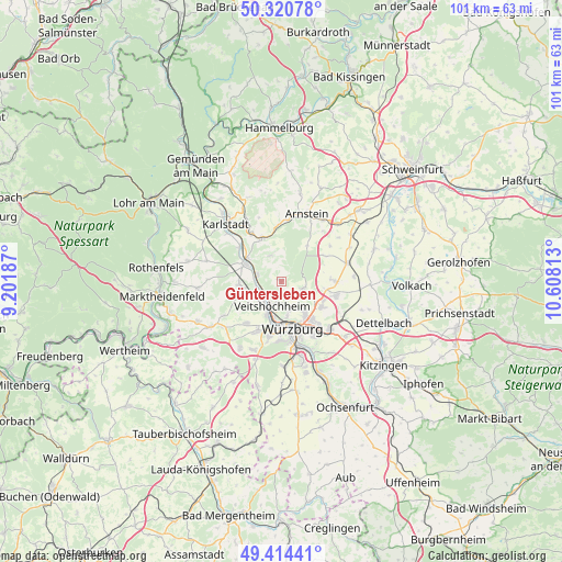
Güntersleben GPS coordinates[2]
49° 52' 10.992" North, 9° 54' 18" East
| Map corner | latitude | longitude |
|---|---|---|
| Upper-left | 50.32078°, | 9.20187° |
| Center: | 49.86972°, | 9.905° |
| Lower-right: | 49.41441°, | 10.60813° |
| Map W x H: | 100.8×100.8 km | = 62.6×62.6mi |
| max Lat: | 55.01917° ⇑67.2% North |
| Güntersleben: | 49.86972° |
| min Lat: | ⇓32.8% South 47.40724° |
| min Long | Güntersleben | max Long |
| 5.92978° | 9.905° | 14.98853° |
| W 48.6%⇐ | ⇒51.4% E |
Elevation
Elevation of Güntersleben is 267 m = 876 ft, and this is 17.9 m = 59 ft above average elevation for this country.
| Max E: |
1256 m = 4121 ft | 43.8% |
| Güntersleben | 267 m 876 ft | |
| Avg. | 249.1 m = 817 ft | |
Min E: |
-5 m = -16 ft | 56.2% |
See also: Germany elevation on elevation.city.
Geographical zone
Güntersleben is located in North temperate zone (between Tropic of Cancer and the Arctic Circle). Distance of this North polar circle is 1856.2 km =1153.4 mi to North.| Distance of | km | miles | from Güntersleben |
|---|---|---|---|
| North Pole | 4462.1 | 2772.6 | to North |
| Arctic Circle | 1856.2 | 1153.4 | to North |
| Tropic Cancer | 2939.1 | 1826.3 | to South |
| Equator | 5545 | 3445.5 | to South |


Nearby cities:
15 places around Güntersleben: (largest is in red/bold)
• Erlabrunn
4.5 km =2.8 mi,  255°
255°
• Estenfeld
8.5 km =5.3 mi,  122°
122°
• Gadheim
2.7 km =1.7 mi,  178°
178°
• Himmelstadt
9.5 km =5.9 mi,  309°
309°
• Höchberg
9.6 km =6 mi,  189°
189°
• Kürnach
9.5 km =5.9 mi,  103°
103°
• Margetshöchheim
4.6 km =2.9 mi,  219°
219°
• Retzstadt
5 km =3.1 mi,  340°
340°
• Rimpar
4 km =2.5 mi,  110°
110°
• Thüngen
8.6 km =5.3 mi, 337°
• Thüngersheim
4.1 km =2.5 mi,  283°
283°
• Veitshöchheim
4.4 km =2.7 mi,  202°
202°
• Würzburg
9.1 km =5.7 mi,  158°
158°
• Zell am Main
6.9 km =4.3 mi, 201°
• Zellingen
7 km =4.3 mi,  296°
296°
Sources, notices
• [Note1] Compared only with cities in Germany existing in our database
• [Src1] Map data: © OpenStreetMap contributors (CC-BY-SA)
• [Src2] Other city data from geonames.org with taken over terms of usage.
• [Src3] Geographical zone / Annual Mean Temperature by Robert A. Rohde @ Wikipedia
