Mützel geodata
Mützel (Saxony-Anhalt) is a populated place; located in Germany in Europe/Berlin (GMT+2) time zone. With population of 556 people, there are 9050 cities with bigger population in this country. Compared to other cities in Germany, 76% of cities are located further ↓South; 84.3% of cities are located further ←West and 84.9% of cities have higher elevation than Mützel. Note1


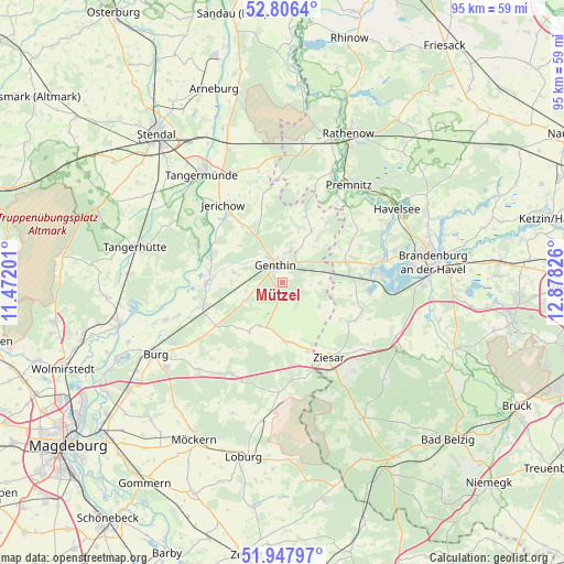
Mützel GPS coordinates[2]
52° 22' 45.372" North, 12° 10' 30.468" East
| Map corner | latitude | longitude |
|---|---|---|
| Upper-left | 52.8064°, | 11.47201° |
| Center: | 52.37927°, | 12.17513° |
| Lower-right: | 51.94797°, | 12.87826° |
| Map W x H: | 95.4×95.4 km | = 59.3×59.3mi |
| max Lat: | 55.01917° ⇑24% North |
| Mützel: | 52.37927° |
| min Lat: | ⇓76% South 47.40724° |
| min Long | Mützel | max Long |
| 5.92978° | 12.17513° | 14.98853° |
| W 84.3%⇐ | ⇒15.7% E |
Elevation
Elevation of Mützel is 35 m = 115 ft, and this is 214.1 m = 702 ft below average elevation for this country.
| Max E: |
1256 m = 4121 ft | 84.9% |
| Avg. | 249.1 m = 817 ft | |
| Mützel | 35 m = 115 ft | |
Min E: |
-5 m = -16 ft | 15.1% |
See also: Germany elevation on elevation.city.
Geographical zone
Mützel is located in North temperate zone (between Tropic of Cancer and the Arctic Circle). Distance of this North polar circle is 1577.1 km =980 mi to North.| Distance of | km | miles | from Mützel |
|---|---|---|---|
| North Pole | 4183 | 2599.2 | to North |
| Arctic Circle | 1577.1 | 980 | to North |
| Tropic Cancer | 3218.1 | 1999.6 | to South |
| Equator | 5824 | 3618.9 | to South |


Nearby cities:
15 places around Mützel: (largest is in red/bold)
• Bensdorf
11.5 km =7.1 mi,  68°
68°
• Bittkau
14.8 km =9.2 mi,  284°
284°
• Brettin
5.3 km =3.3 mi,  5°
5°
• Ferchland
13.7 km =8.5 mi,  299°
299°
• Genthin
3.2 km =2 mi,  340°
340°
• Gladau
10.1 km =6.3 mi,  214°
214°
• Grieben
15.9 km =9.9 mi,  293°
293°
• Kade
6.2 km =3.9 mi,  89°
89°
• Karow
7.1 km =4.4 mi,  122°
122°
• Redekin
11.9 km =7.4 mi,  325°
325°
• Roßdorf
5.7 km =3.5 mi,  22°
22°
• Schlagenthin
11.9 km =7.4 mi,  36°
36°
• Tucheim
10 km =6.2 mi,  176°
176°
• Wusterwitz
14.3 km =8.9 mi,  95°
95°
• Ziesar
14.8 km =9.2 mi,  148°
148°
Sources, notices
• [Note1] Compared only with cities in Germany existing in our database
• [Src1] Map data: © OpenStreetMap contributors (CC-BY-SA)
• [Src2] Other city data from geonames.org with taken over terms of usage.
• [Src3] Geographical zone / Annual Mean Temperature by Robert A. Rohde @ Wikipedia
