Jesewitz geodata
Jesewitz (Saxony) is a seat of a fourth-order administrative division; located in Germany in Europe/Berlin (GMT+2) time zone. With population of 3,174 people, there are 3851 cities with bigger population in this country. Compared to other cities in Germany, 65.2% of cities are located further ↓South; 88.5% of cities are located further ←West and 64.1% of cities have higher elevation than Jesewitz. Note1


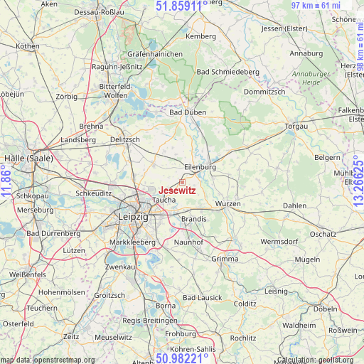
Jesewitz GPS coordinates[2]
51° 25' 21.936" North, 12° 33' 47.232" East
| Map corner | latitude | longitude |
|---|---|---|
| Upper-left | 51.85911°, | 11.86° |
| Center: | 51.42276°, | 12.56312° |
| Lower-right: | 50.98221°, | 13.26625° |
| Map W x H: | 97.5×97.5 km | = 60.6×60.6mi |
| max Lat: | 55.01917° ⇑34.8% North |
| Jesewitz: | 51.42276° |
| min Lat: | ⇓65.2% South 47.40724° |
| min Long | Jesewitz | max Long |
| 5.92978° | 12.56312° | 14.98853° |
| W 88.5%⇐ | ⇒11.5% E |
Elevation
Elevation of Jesewitz is 126 m = 413 ft, and this is 123.1 m = 404 ft below average elevation for this country.
| Max E: |
1256 m = 4121 ft | 64.1% |
| Avg. | 249.1 m = 817 ft | |
| Jesewitz | 126 m = 413 ft | |
Min E: |
-5 m = -16 ft | 35.9% |
See also: Germany elevation on elevation.city.
Geographical zone
Jesewitz is located in North temperate zone (between Tropic of Cancer and the Arctic Circle). Distance of this North polar circle is 1683.5 km =1046.1 mi to North.| Distance of | km | miles | from Jesewitz |
|---|---|---|---|
| North Pole | 4289.4 | 2665.3 | to North |
| Arctic Circle | 1683.5 | 1046.1 | to North |
| Tropic Cancer | 3111.8 | 1933.6 | to South |
| Equator | 5717.7 | 3552.8 | to South |


Nearby cities:
15 places around Jesewitz: (largest is in red/bold)
• Bennewitz
12.5 km =7.8 mi,  123°
123°
• Borsdorf
8.4 km =5.2 mi,  194°
194°
• Brandis
10.2 km =6.3 mi,  161°
161°
• Doberschütz
15.3 km =9.5 mi,  56°
56°
• Eilenburg
6.4 km =4 mi,  49°
49°
• Krostitz
8.8 km =5.5 mi,  299°
299°
• Laußig
14.5 km =9 mi,  18°
18°
• Machern
7.9 km =4.9 mi,  142°
142°
• Naunhof
16.2 km =10.1 mi,  173°
173°
• Rackwitz
12.5 km =7.8 mi,  275°
275°
• Taucha
7.1 km =4.4 mi,  231°
231°
• Thallwitz
8.4 km =5.2 mi,  81°
81°
• Wurzen
13.5 km =8.4 mi, 115°
• Zschepplin
9 km =5.6 mi, 16°
• Zschortau
15.5 km =9.6 mi,  293°
293°
Sources, notices
• [Note1] Compared only with cities in Germany existing in our database
• [Src1] Map data: © OpenStreetMap contributors (CC-BY-SA)
• [Src2] Other city data from geonames.org with taken over terms of usage.
• [Src3] Geographical zone / Annual Mean Temperature by Robert A. Rohde @ Wikipedia
