Bennewitz geodata
Bennewitz (Saxony) is a section of populated place; located in Germany in Europe/Berlin (GMT+2) time zone. With population of 5,211 people, there are 2732 cities with bigger population in this country. Compared to other cities in Germany, 64.2% of cities are located further ↓South; 89.9% of cities are located further ←West and 66% of cities have higher elevation than Bennewitz. Note1


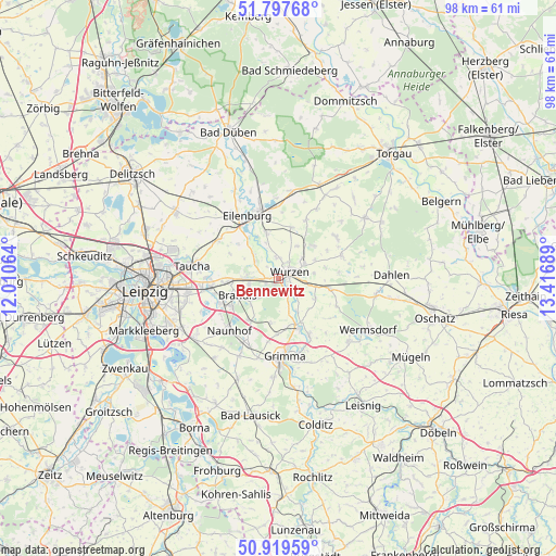
Bennewitz GPS coordinates[2]
51° 21' 38.664" North, 12° 42' 49.536" East
| Map corner | latitude | longitude |
|---|---|---|
| Upper-left | 51.79768°, | 12.01064° |
| Center: | 51.36074°, | 12.71376° |
| Lower-right: | 50.91959°, | 13.41689° |
| Map W x H: | 97.6×97.6 km | = 60.6×60.6mi |
| max Lat: | 55.01917° ⇑35.8% North |
| Bennewitz: | 51.36074° |
| min Lat: | ⇓64.2% South 47.40724° |
| min Long | Bennewitz | max Long |
| 5.92978° | 12.71376° | 14.98853° |
| W 89.9%⇐ | ⇒10.1% E |
Elevation
Elevation of Bennewitz is 114 m = 374 ft, and this is 135.1 m = 443 ft below average elevation for this country.
| Max E: |
1256 m = 4121 ft | 66% |
| Avg. | 249.1 m = 817 ft | |
| Bennewitz | 114 m = 374 ft | |
Min E: |
-5 m = -16 ft | 34% |
See also: Germany elevation on elevation.city.
Geographical zone
Bennewitz is located in North temperate zone (between Tropic of Cancer and the Arctic Circle). Distance of this North polar circle is 1690.4 km =1050.4 mi to North.| Distance of | km | miles | from Bennewitz |
|---|---|---|---|
| North Pole | 4296.3 | 2669.6 | to North |
| Arctic Circle | 1690.4 | 1050.4 | to North |
| Tropic Cancer | 3104.9 | 1929.3 | to South |
| Equator | 5710.8 | 3548.5 | to South |


Nearby cities:
15 places around Bennewitz: (largest is in red/bold)
• Borsdorf
12.6 km =7.8 mi,  264°
264°
• Brandis
7.7 km =4.8 mi,  249°
249°
• Doberschütz
15.5 km =9.6 mi,  8°
8°
• Eilenburg
12.3 km =7.6 mi,  333°
333°
• Falkenhain
11.7 km =7.3 mi,  68°
68°
• Grimma
14.1 km =8.8 mi,  178°
178°
• Hohburg
8.5 km =5.3 mi,  48°
48°
• Jesewitz
12.5 km =7.8 mi,  303°
303°
• Machern
5.6 km =3.5 mi,  276°
276°
• Naunhof
12.7 km =7.9 mi,  223°
223°
• Nerchau
11.3 km =7 mi,  152°
152°
• Taucha
16.2 km =10.1 mi, 278°
• Thallwitz
8.3 km =5.2 mi,  345°
345°
• Trebsen
8.5 km =5.3 mi,  160°
160°
• Wurzen
2.1 km =1.3 mi,  58°
58°
Sources, notices
• [Note1] Compared only with cities in Germany existing in our database
• [Src1] Map data: © OpenStreetMap contributors (CC-BY-SA)
• [Src2] Other city data from geonames.org with taken over terms of usage.
• [Src3] Geographical zone / Annual Mean Temperature by Robert A. Rohde @ Wikipedia
