Behnsdorf geodata
Behnsdorf (Saxony-Anhalt) is a populated place; located in Germany in Europe/Berlin (GMT+2) time zone. With population of 686 people, there are 8384 cities with bigger population in this country. Compared to other cities in Germany, 75.3% of cities are located further ↓South; 69.2% of cities are located further ←West and 63% of cities have higher elevation than Behnsdorf. Note1


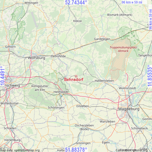
Behnsdorf GPS coordinates[2]
52° 18' 56.52" North, 11° 9' 7.992" East
| Map corner | latitude | longitude |
|---|---|---|
| Upper-left | 52.74344°, | 10.4491° |
| Center: | 52.3157°, | 11.15222° |
| Lower-right: | 51.88378°, | 11.85535° |
| Map W x H: | 95.6×95.6 km | = 59.4×59.4mi |
| max Lat: | 55.01917° ⇑24.7% North |
| Behnsdorf: | 52.3157° |
| min Lat: | ⇓75.3% South 47.40724° |
| min Long | Behnsdorf | max Long |
| 5.92978° | 11.15222° | 14.98853° |
| W 69.2%⇐ | ⇒30.8% E |
Elevation
Elevation of Behnsdorf is 132 m = 433 ft, and this is 117.1 m = 384 ft below average elevation for this country.
| Max E: |
1256 m = 4121 ft | 63% |
| Avg. | 249.1 m = 817 ft | |
| Behnsdorf | 132 m = 433 ft | |
Min E: |
-5 m = -16 ft | 37% |
See also: Germany elevation on elevation.city.
Geographical zone
Behnsdorf is located in North temperate zone (between Tropic of Cancer and the Arctic Circle). Distance of this North polar circle is 1584.2 km =984.4 mi to North.| Distance of | km | miles | from Behnsdorf |
|---|---|---|---|
| North Pole | 4190.1 | 2603.6 | to North |
| Arctic Circle | 1584.2 | 984.4 | to North |
| Tropic Cancer | 3211 | 1995.2 | to South |
| Equator | 5817 | 3614.5 | to South |


Nearby cities:
15 places around Behnsdorf: (largest is in red/bold)
• Altenhausen
9.2 km =5.7 mi,  130°
130°
• Beendorf
9.2 km =5.7 mi,  208°
208°
• Bregenstedt
8.4 km =5.2 mi,  144°
144°
• Eimersleben
10.9 km =6.8 mi,  162°
162°
• Etingen
8.8 km =5.5 mi,  7°
7°
• Flechtingen
6.3 km =3.9 mi,  74°
74°
• Grasleben
9.4 km =5.8 mi,  263°
263°
• Hörsingen
4 km =2.5 mi,  177°
177°
• Ivenrode
7.2 km =4.5 mi, 131°
• Mariental
12.3 km =7.6 mi,  248°
248°
• Rätzlingen
9.9 km =6.2 mi,  344°
344°
• Siestedt
4.1 km =2.5 mi,  273°
273°
• Süplingen
12.1 km =7.5 mi,  104°
104°
• Walbeck
7.2 km =4.5 mi,  235°
235°
• Weferlingen
6.4 km =4 mi, 266°
Sources, notices
• [Note1] Compared only with cities in Germany existing in our database
• [Src1] Map data: © OpenStreetMap contributors (CC-BY-SA)
• [Src2] Other city data from geonames.org with taken over terms of usage.
• [Src3] Geographical zone / Annual Mean Temperature by Robert A. Rohde @ Wikipedia
