Stolpen geodata
Stolpen (Saxony) is a populated place; located in Germany in Europe/Berlin (GMT+2) time zone. With population of 6,284 people, there are 2371 cities with bigger population in this country. Compared to other cities in Germany, 58.9% of cities are located further ↓South; 98.3% of cities are located further ←West and 62.5% of cities have lower elevation than Stolpen. Note1


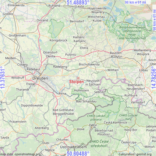
Stolpen GPS coordinates[2]
51° 2' 56.436" North, 14° 4' 45.948" East
| Map corner | latitude | longitude |
|---|---|---|
| Upper-left | 51.48893°, | 13.37631° |
| Center: | 51.04901°, | 14.07943° |
| Lower-right: | 50.60488°, | 14.78256° |
| Map W x H: | 98.3×98.3 km | = 61.1×61.1mi |
| max Lat: | 55.01917° ⇑41.1% North |
| Stolpen: | 51.04901° |
| min Lat: | ⇓58.9% South 47.40724° |
| min Long | Stolpen | max Long |
| 5.92978° | 14.07943° | 14.98853° |
| W 98.3%⇐ | ⇒1.7% E |
Elevation
Elevation of Stolpen is 305 m = 1001 ft, and this is 55.9 m = 183 ft above average elevation for this country.
| Max E: |
1256 m = 4121 ft | 37.5% |
| Stolpen | 305 m 1001 ft | |
| Avg. | 249.1 m = 817 ft | |
Min E: |
-5 m = -16 ft | 62.5% |
See also: Germany elevation on elevation.city.
Geographical zone
Stolpen is located in North temperate zone (between Tropic of Cancer and the Arctic Circle). Distance of this North polar circle is 1725.1 km =1071.9 mi to North.| Distance of | km | miles | from Stolpen |
|---|---|---|---|
| North Pole | 4330.9 | 2691.1 | to North |
| Arctic Circle | 1725.1 | 1071.9 | to North |
| Tropic Cancer | 3070.2 | 1907.7 | to South |
| Equator | 5676.1 | 3527 | to South |


Nearby cities:
15 places around Stolpen: (largest is in red/bold)
• Arnsdorf
7.9 km =4.9 mi,  309°
309°
• Berthelsdorf
10 km =6.2 mi,  91°
91°
• Bischofswerda
11.2 km =7 mi,  38°
38°
• Dürrröhrsdorf
6 km =3.7 mi,  253°
253°
• Frankenthal
9.4 km =5.8 mi,  12°
12°
• Großharthau
6.6 km =4.1 mi, 12°
• Großröhrsdorf
11.5 km =7.1 mi,  338°
338°
• Hauswalde
11.5 km =7.1 mi,  2°
2°
• Hohnstein
8.1 km =5 mi,  162°
162°
• Lohmen
8.6 km =5.3 mi,  218°
218°
• Neustadt in Sachsen
9.9 km =6.2 mi,  103°
103°
• Porschdorf
12.4 km =7.7 mi, 164°
• Rammenau
11.8 km =7.3 mi,  18°
18°
• Stadt Wehlen
10.7 km =6.6 mi,  198°
198°
• Struppen
13.6 km =8.5 mi, 198°
Sources, notices
• [Note1] Compared only with cities in Germany existing in our database
• [Src1] Map data: © OpenStreetMap contributors (CC-BY-SA)
• [Src2] Other city data from geonames.org with taken over terms of usage.
• [Src3] Geographical zone / Annual Mean Temperature by Robert A. Rohde @ Wikipedia
