Großharthau geodata
Großharthau (Saxony) is a seat of a fourth-order administrative division; located in Germany in Europe/Berlin (GMT+2) time zone. With population of 3,415 people, there are 3679 cities with bigger population in this country. Compared to other cities in Germany, 60% of cities are located further ↓South; 98.3% of cities are located further ←West and 57.9% of cities have lower elevation than Großharthau. Note1


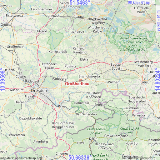
Großharthau GPS coordinates[2]
51° 6' 24.984" North, 14° 5' 56.796" East
| Map corner | latitude | longitude |
|---|---|---|
| Upper-left | 51.5463°, | 13.39599° |
| Center: | 51.10694°, | 14.09911° |
| Lower-right: | 50.66336°, | 14.80224° |
| Map W x H: | 98.2×98.2 km | = 61×61mi |
| max Lat: | 55.01917° ⇑40% North |
| Großharthau: | 51.10694° |
| min Lat: | ⇓60% South 47.40724° |
| min Long | Großharthau | max Long |
| 5.92978° | 14.09911° | 14.98853° |
| W 98.3%⇐ | ⇒1.7% E |
Elevation
Elevation of Großharthau is 278 m = 912 ft, and this is 28.9 m = 95 ft above average elevation for this country.
| Max E: |
1256 m = 4121 ft | 42.1% |
| Großharthau | 278 m 912 ft | |
| Avg. | 249.1 m = 817 ft | |
Min E: |
-5 m = -16 ft | 57.9% |
See also: Germany elevation on elevation.city.
Geographical zone
Großharthau is located in North temperate zone (between Tropic of Cancer and the Arctic Circle). Distance of this North polar circle is 1718.6 km =1067.9 mi to North.| Distance of | km | miles | from Großharthau |
|---|---|---|---|
| North Pole | 4324.5 | 2687.1 | to North |
| Arctic Circle | 1718.6 | 1067.9 | to North |
| Tropic Cancer | 3076.6 | 1911.7 | to South |
| Equator | 5682.6 | 3531 | to South |


Nearby cities:
15 places around Großharthau: (largest is in red/bold)
• Arnsdorf
7.6 km =4.7 mi,  259°
259°
• Berthelsdorf
10.9 km =6.8 mi,  127°
127°
• Bischofswerda
6.1 km =3.8 mi,  67°
67°
• Burkau
9.2 km =5.7 mi,  34°
34°
• Demitz-Thumitz
11 km =6.8 mi, 69°
• Dürrröhrsdorf
10.8 km =6.7 mi,  221°
221°
• Frankenthal
2.8 km =1.7 mi,  14°
14°
• Großröhrsdorf
7 km =4.3 mi,  307°
307°
• Hauswalde
5.1 km =3.2 mi,  349°
349°
• Lichtenberg
12.5 km =7.8 mi, 312°
• Neustadt in Sachsen
12 km =7.5 mi,  136°
136°
• Ohorn
8.1 km =5 mi,  333°
333°
• Rammenau
5.4 km =3.4 mi, 26°
• Steina
10.9 km =6.8 mi,  341°
341°
• Stolpen
6.6 km =4.1 mi,  192°
192°
Sources, notices
• [Note1] Compared only with cities in Germany existing in our database
• [Src1] Map data: © OpenStreetMap contributors (CC-BY-SA)
• [Src2] Other city data from geonames.org with taken over terms of usage.
• [Src3] Geographical zone / Annual Mean Temperature by Robert A. Rohde @ Wikipedia
