Bischofswerda geodata
Bischofswerda (Saxony) is a populated place; located in Germany in Europe/Berlin (GMT+2) time zone. With population of 13,085 people, there are 1229 cities with bigger population in this country. Compared to other cities in Germany, 60.3% of cities are located further ↓South; 98.6% of cities are located further ←West and 60.5% of cities have lower elevation than Bischofswerda. Note1


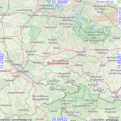
Bischofswerda GPS coordinates[2]
51° 7' 39.756" North, 14° 10' 47.064" East
| Map corner | latitude | longitude |
|---|---|---|
| Upper-left | 51.56688°, | 13.47662° |
| Center: | 51.12771°, | 14.17974° |
| Lower-right: | 50.68433°, | 14.88287° |
| Map W x H: | 98.1×98.1 km | = 61×61mi |
| max Lat: | 55.01917° ⇑39.7% North |
| Bischofswerda: | 51.12771° |
| min Lat: | ⇓60.3% South 47.40724° |
| min Long | Bischofswerda | max Long |
| 5.92978° | 14.17974° | 14.98853° |
| W 98.6%⇐ | ⇒1.4% E |
Elevation
Elevation of Bischofswerda is 293 m = 961 ft, and this is 43.9 m = 144 ft above average elevation for this country.
| Max E: |
1256 m = 4121 ft | 39.5% |
| Bischofswerda | 293 m 961 ft | |
| Avg. | 249.1 m = 817 ft | |
Min E: |
-5 m = -16 ft | 60.5% |
See also: Germany elevation on elevation.city.
Geographical zone
Bischofswerda is located in North temperate zone (between Tropic of Cancer and the Arctic Circle). Distance of this North polar circle is 1716.3 km =1066.5 mi to North.| Distance of | km | miles | from Bischofswerda |
|---|---|---|---|
| North Pole | 4322.2 | 2685.7 | to North |
| Arctic Circle | 1716.3 | 1066.5 | to North |
| Tropic Cancer | 3078.9 | 1913.1 | to South |
| Equator | 5684.9 | 3532.4 | to South |


Nearby cities:
15 places around Bischofswerda: (largest is in red/bold)
• Berthelsdorf
9.5 km =5.9 mi,  161°
161°
• Burkau
5.4 km =3.4 mi,  355°
355°
• Demitz-Thumitz
4.9 km =3 mi,  71°
71°
• Elstra
11 km =6.8 mi,  342°
342°
• Frankenthal
5 km =3.1 mi,  274°
274°
• Großharthau
6.1 km =3.8 mi,  247°
247°
• Großröhrsdorf
11.4 km =7.1 mi,  279°
279°
• Göda
11.2 km =7 mi,  60°
60°
• Hauswalde
7.1 km =4.4 mi,  292°
292°
• Neukirch/Lausitz
9.6 km =6 mi,  110°
110°
• Neustadt in Sachsen
11.4 km =7.1 mi,  166°
166°
• Ohorn
10.5 km =6.5 mi,  297°
297°
• Panschwitz-Kuckau
11.9 km =7.4 mi,  6°
6°
• Rammenau
4.1 km =2.5 mi,  307°
307°
• Stolpen
11.2 km =7 mi,  218°
218°
Sources, notices
• [Note1] Compared only with cities in Germany existing in our database
• [Src1] Map data: © OpenStreetMap contributors (CC-BY-SA)
• [Src2] Other city data from geonames.org with taken over terms of usage.
• [Src3] Geographical zone / Annual Mean Temperature by Robert A. Rohde @ Wikipedia
