Berthelsdorf geodata
Berthelsdorf (Saxony) is a populated place; located in Germany in Europe/Berlin (GMT+2) time zone. With population of 1,813 people, there are 5326 cities with bigger population in this country. Compared to other cities in Germany, 58.9% of cities are located further ↓South; 98.7% of cities are located further ←West and 67.1% of cities have lower elevation than Berthelsdorf. Note1
Administrative division(s):
- Level 1: Saxony
- Level 3: Landkreis Sächsische Schweiz
- Level 4: Neustadt i. Sa.


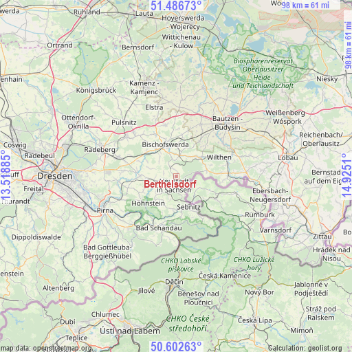
Berthelsdorf GPS coordinates[2]
51° 2' 48.444" North, 14° 13' 19.092" East
| Map corner | latitude | longitude |
|---|---|---|
| Upper-left | 51.48673°, | 13.51885° |
| Center: | 51.04679°, | 14.22197° |
| Lower-right: | 50.60263°, | 14.9251° |
| Map W x H: | 98.3×98.3 km | = 61.1×61.1mi |
| max Lat: | 55.01917° ⇑41.1% North |
| Berthelsdorf: | 51.04679° |
| min Lat: | ⇓58.9% South 47.40724° |
| min Long | Berthelsdorf | max Long |
| 5.92978° | 14.22197° | 14.98853° |
| W 98.7%⇐ | ⇒1.3% E |
Elevation
Elevation of Berthelsdorf is 336 m = 1102 ft, and this is 86.9 m = 285 ft above average elevation for this country.
| Max E: |
1256 m = 4121 ft | 32.9% |
| Berthelsdorf | 336 m 1102 ft | |
| Avg. | 249.1 m = 817 ft | |
Min E: |
-5 m = -16 ft | 67.1% |
See also: Germany elevation on elevation.city.
Geographical zone
Berthelsdorf is located in North temperate zone (between Tropic of Cancer and the Arctic Circle). Distance of this North polar circle is 1725.3 km =1072.1 mi to North.| Distance of | km | miles | from Berthelsdorf |
|---|---|---|---|
| North Pole | 4331.2 | 2691.3 | to North |
| Arctic Circle | 1725.3 | 1072.1 | to North |
| Tropic Cancer | 3070 | 1907.6 | to South |
| Equator | 5675.9 | 3526.8 | to South |


Nearby cities:
15 places around Berthelsdorf: (largest is in red/bold)
• Bischofswerda
9.5 km =5.9 mi,  341°
341°
• Demitz-Thumitz
10.7 km =6.6 mi,  9°
9°
• Frankenthal
12.3 km =7.6 mi,  319°
319°
• Großharthau
10.9 km =6.8 mi,  307°
307°
• Hohnstein
10.6 km =6.6 mi,  225°
225°
• Neukirch/Lausitz
8.2 km =5.1 mi,  46°
46°
• Neustadt in Sachsen
2.1 km =1.3 mi,  188°
188°
• Porschdorf
13.4 km =8.3 mi,  209°
209°
• Rammenau
13 km =8.1 mi,  331°
331°
• Rathmannsdorf
14.1 km =8.8 mi,  203°
203°
• Sebnitz
8.8 km =5.5 mi,  154°
154°
• Sohland
13.8 km =8.6 mi,  92°
92°
• Steinigtwolmsdorf
8.8 km =5.5 mi,  78°
78°
• Stolpen
10 km =6.2 mi,  271°
271°
• Wilthen
13.2 km =8.2 mi,  64°
64°
Sources, notices
• [Note1] Compared only with cities in Germany existing in our database
• [Src1] Map data: © OpenStreetMap contributors (CC-BY-SA)
• [Src2] Other city data from geonames.org with taken over terms of usage.
• [Src3] Geographical zone / Annual Mean Temperature by Robert A. Rohde @ Wikipedia
