Bad Schwartau geodata
Bad Schwartau (Schleswig-Holstein) is a populated place; located in Germany in Europe/Berlin (GMT+2) time zone. With population of 19,722 people, there are 790 cities with bigger population in this country. Compared to other cities in Germany, 91.5% of cities are located further ↓South; 62.4% of cities are located further ←West and 93.9% of cities have higher elevation than Bad Schwartau. Note1
Administrative division(s):
- Level 1: Schleswig-Holstein
- Level 3: Kreis Ostholstein
- Level 4: Bad Schwartau


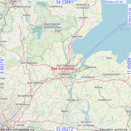
Bad Schwartau GPS coordinates[2]
53° 55' 7.932" North, 10° 41' 48.876" East
| Map corner | latitude | longitude |
|---|---|---|
| Upper-left | 54.33091°, | 9.99379° |
| Center: | 53.91887°, | 10.69691° |
| Lower-right: | 53.50272°, | 11.40004° |
| Map W x H: | 92.1×92.1 km | = 57.2×57.2mi |
| max Lat: | 55.01917° ⇑8.5% North |
| Bad Schwartau: | 53.91887° |
| min Lat: | ⇓91.5% South 47.40724° |
| min Long | Bad Schwartau | max Long |
| 5.92978° | 10.69691° | 14.98853° |
| W 62.4%⇐ | ⇒37.6% E |
Elevation
Elevation of Bad Schwartau is 11 m = 36 ft, and this is 238.1 m = 781 ft below average elevation for this country.
| Max E: |
1256 m = 4121 ft | 93.9% |
| Avg. | 249.1 m = 817 ft | |
| Bad Schwartau | 11 m = 36 ft | |
Min E: |
-5 m = -16 ft | 6.1% |
See also: Germany elevation on elevation.city.
Geographical zone
Bad Schwartau is located in North temperate zone (between Tropic of Cancer and the Arctic Circle). Distance of this North polar circle is 1406 km =873.6 mi to North.| Distance of | km | miles | from Bad Schwartau |
|---|---|---|---|
| North Pole | 4011.8 | 2492.8 | to North |
| Arctic Circle | 1406 | 873.6 | to North |
| Tropic Cancer | 3389.3 | 2106 | to South |
| Equator | 5995.2 | 3725.2 | to South |


Nearby cities:
15 places around Bad Schwartau: (largest is in red/bold)
• Ahrensbök
12.8 km =8 mi,  321°
321°
• Badendorf
10.3 km =6.4 mi,  235°
235°
• Groß Grönau
13.7 km =8.5 mi,  165°
165°
• Hamberge
12.1 km =7.5 mi,  218°
218°
• Heilshoop
11.4 km =7.1 mi,  249°
249°
• Lübeck
5.6 km =3.5 mi,  186°
186°
• Mönkhagen
9.8 km =6.1 mi,  257°
257°
• Ratekau
4.2 km =2.6 mi,  34°
34°
• Scharbeutz
13.2 km =8.2 mi,  15°
15°
• Selmsdorf
11.4 km =7.1 mi,  110°
110°
• Stockelsdorf
4.4 km =2.7 mi,  227°
227°
• Timmendorfer Strand
10 km =6.2 mi, 31°
• Travemünde
12.4 km =7.7 mi,  66°
66°
• Wesenberg
13.5 km =8.4 mi, 225°
• Zarpen
13.2 km =8.2 mi, 243°
Sources, notices
• [Note1] Compared only with cities in Germany existing in our database
• [Src1] Map data: © OpenStreetMap contributors (CC-BY-SA)
• [Src2] Other city data from geonames.org with taken over terms of usage.
• [Src3] Geographical zone / Annual Mean Temperature by Robert A. Rohde @ Wikipedia
