Ratekau geodata
Ratekau (Schleswig-Holstein) is a seat of a fourth-order administrative division; located in Germany in Europe/Berlin (GMT+2) time zone. With population of 15,921 people, there are 1009 cities with bigger population in this country. Compared to other cities in Germany, 92% of cities are located further ↓South; 63% of cities are located further ←West and 91.6% of cities have higher elevation than Ratekau. Note1


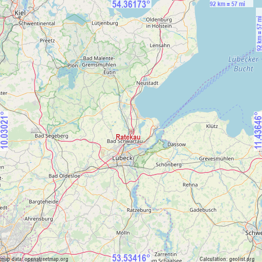
Ratekau GPS coordinates[2]
53° 57' 0" North, 10° 43' 59.988" East
| Map corner | latitude | longitude |
|---|---|---|
| Upper-left | 54.36173°, | 10.03021° |
| Center: | 53.95°, | 10.73333° |
| Lower-right: | 53.53416°, | 11.43646° |
| Map W x H: | 92×92 km | = 57.2×57.2mi |
| max Lat: | 55.01917° ⇑8% North |
| Ratekau: | 53.95° |
| min Lat: | ⇓92% South 47.40724° |
| min Long | Ratekau | max Long |
| 5.92978° | 10.73333° | 14.98853° |
| W 63%⇐ | ⇒37% E |
Elevation
Elevation of Ratekau is 17 m = 56 ft, and this is 232.1 m = 761 ft below average elevation for this country.
| Max E: |
1256 m = 4121 ft | 91.6% |
| Avg. | 249.1 m = 817 ft | |
| Ratekau | 17 m = 56 ft | |
Min E: |
-5 m = -16 ft | 8.4% |
See also: Germany elevation on elevation.city.
Geographical zone
Ratekau is located in North temperate zone (between Tropic of Cancer and the Arctic Circle). Distance of this North polar circle is 1402.5 km =871.5 mi to North.| Distance of | km | miles | from Ratekau |
|---|---|---|---|
| North Pole | 4008.4 | 2490.7 | to North |
| Arctic Circle | 1402.5 | 871.5 | to North |
| Tropic Cancer | 3392.8 | 2108.2 | to South |
| Equator | 5998.7 | 3727.4 | to South |


Nearby cities:
15 places around Ratekau: (largest is in red/bold)
• Ahrensbök
12.3 km =7.6 mi,  302°
302°
• Bad Schwartau
4.2 km =2.6 mi,  214°
214°
• Badendorf
14.3 km =8.9 mi,  229°
229°
• Hamberge
16.3 km =10.1 mi,  217°
217°
• Heilshoop
15 km =9.3 mi,  240°
240°
• Lübeck
9.5 km =5.9 mi,  198°
198°
• Mönkhagen
13.2 km =8.2 mi,  245°
245°
• Pötenitz
12.5 km =7.8 mi,  90°
90°
• Scharbeutz
9.3 km =5.8 mi,  6°
6°
• Selmsdorf
11.2 km =7 mi,  132°
132°
• Sierksdorf
13.2 km =8.2 mi, 9°
• Stockelsdorf
8.6 km =5.3 mi, 221°
• Süsel
14.8 km =9.2 mi,  351°
351°
• Timmendorfer Strand
5.8 km =3.6 mi,  29°
29°
• Travemünde
9.1 km =5.7 mi,  80°
80°
Sources, notices
• [Note1] Compared only with cities in Germany existing in our database
• [Src1] Map data: © OpenStreetMap contributors (CC-BY-SA)
• [Src2] Other city data from geonames.org with taken over terms of usage.
• [Src3] Geographical zone / Annual Mean Temperature by Robert A. Rohde @ Wikipedia
