Stöckelsberg geodata
Stöckelsberg (Bavaria) is a populated place; located in Germany in Europe/Berlin (GMT+2) time zone. With population of 560 people, there are 9028 cities with bigger population in this country. Compared to other cities in Germany, 77.4% of cities are located further ↑North; 73.3% of cities are located further ←West and 91.2% of cities have lower elevation than Stöckelsberg. Note1
Administrative division(s):
- Level 1: Bavaria
- Level 2: Upper Palatinate
- Level 3: Landkreis Neumarkt in der Oberpfalz
- Level 4: Berg bei Neumarkt in der Oberpfalz


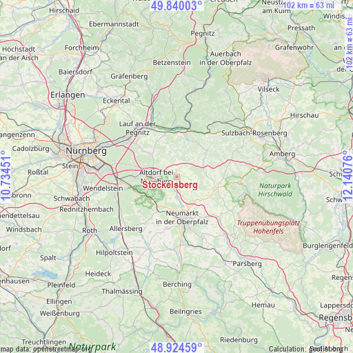
Stöckelsberg GPS coordinates[2]
49° 23' 3.984" North, 11° 26' 15.468" East
| Map corner | latitude | longitude |
|---|---|---|
| Upper-left | 49.84003°, | 10.73451° |
| Center: | 49.38444°, | 11.43763° |
| Lower-right: | 48.92459°, | 12.14076° |
| Map W x H: | 101.8×101.8 km | = 63.3×63.3mi |
| max Lat: | 55.01917° ⇑77.4% North |
| Stöckelsberg: | 49.38444° |
| min Lat: | ⇓22.6% South 47.40724° |
| min Long | Stöckelsberg | max Long |
| 5.92978° | 11.43763° | 14.98853° |
| W 73.3%⇐ | ⇒26.7% E |
Elevation
Elevation of Stöckelsberg is 531 m = 1742 ft, and this is 281.9 m = 925 ft above average elevation for this country.
| Max E: |
1256 m = 4121 ft | 8.8% |
| Stöckelsberg | 531 m 1742 ft | |
| Avg. | 249.1 m = 817 ft | |
Min E: |
-5 m = -16 ft | 91.2% |
See also: Germany elevation on elevation.city.
Geographical zone
Stöckelsberg is located in North temperate zone (between Tropic of Cancer and the Arctic Circle). Distance of this North polar circle is 1910.1 km =1186.9 mi to North.| Distance of | km | miles | from Stöckelsberg |
|---|---|---|---|
| North Pole | 4516 | 2806.1 | to North |
| Arctic Circle | 1910.1 | 1186.9 | to North |
| Tropic Cancer | 2885.1 | 1792.7 | to South |
| Equator | 5491 | 3411.9 | to South |


Nearby cities:
15 places around Stöckelsberg: (largest is in red/bold)
• Alfeld
9.8 km =6.1 mi,  56°
56°
• Altdorf
5.8 km =3.6 mi,  271°
271°
• Berg bei Neumarkt in der Oberpfalz
5.9 km =3.7 mi,  179°
179°
• Burgthann
9.8 km =6.1 mi,  248°
248°
• Engelthal
10.1 km =6.3 mi,  344°
344°
• Happurg
12.4 km =7.7 mi,  11°
11°
• Henfenfeld
13.1 km =8.1 mi, 344°
• Hersbruck
14.1 km =8.8 mi,  358°
358°
• Lauterhofen
12.1 km =7.5 mi,  98°
98°
• Leinburg
11.9 km =7.4 mi,  308°
308°
• Neumarkt in der Oberpfalz
11.7 km =7.3 mi,  171°
171°
• Offenhausen
7.5 km =4.7 mi,  346°
346°
• Pilsach
8.5 km =5.3 mi,  145°
145°
• Postbauer-Heng
10.6 km =6.6 mi,  213°
213°
• Winkelhaid
10.1 km =6.3 mi, 273°
Sources, notices
• [Note1] Compared only with cities in Germany existing in our database
• [Src1] Map data: © OpenStreetMap contributors (CC-BY-SA)
• [Src2] Other city data from geonames.org with taken over terms of usage.
• [Src3] Geographical zone / Annual Mean Temperature by Robert A. Rohde @ Wikipedia
