Hersbruck geodata
Hersbruck (Bavaria) is a populated place; located in Germany in Europe/Berlin (GMT+2) time zone. With population of 12,404 people, there are 1313 cities with bigger population in this country. Compared to other cities in Germany, 75.5% of cities are located further ↑North; 73.2% of cities are located further ←West and 67.6% of cities have lower elevation than Hersbruck. Note1
Administrative division(s):
- Level 1: Bavaria
- Level 2: Regierungsbezirk Mittelfranken
- Level 3: Nürnberger Land
- Level 4: Hersbruck


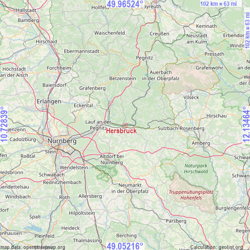
Hersbruck GPS coordinates[2]
49° 30' 38.988" North, 11° 25' 53.436" East
| Map corner | latitude | longitude |
|---|---|---|
| Upper-left | 49.96524°, | 10.72839° |
| Center: | 49.51083°, | 11.43151° |
| Lower-right: | 49.05216°, | 12.13464° |
| Map W x H: | 101.5×101.5 km | = 63.1×63.1mi |
| max Lat: | 55.01917° ⇑75.5% North |
| Hersbruck: | 49.51083° |
| min Lat: | ⇓24.5% South 47.40724° |
| min Long | Hersbruck | max Long |
| 5.92978° | 11.43151° | 14.98853° |
| W 73.2%⇐ | ⇒26.8% E |
Elevation
Elevation of Hersbruck is 340 m = 1115 ft, and this is 90.9 m = 298 ft above average elevation for this country.
| Max E: |
1256 m = 4121 ft | 32.4% |
| Hersbruck | 340 m 1115 ft | |
| Avg. | 249.1 m = 817 ft | |
Min E: |
-5 m = -16 ft | 67.6% |
See also: Germany elevation on elevation.city.
Geographical zone
Hersbruck is located in North temperate zone (between Tropic of Cancer and the Arctic Circle). Distance of this North polar circle is 1896.1 km =1178.2 mi to North.| Distance of | km | miles | from Hersbruck |
|---|---|---|---|
| North Pole | 4502 | 2797.4 | to North |
| Arctic Circle | 1896.1 | 1178.2 | to North |
| Tropic Cancer | 2899.2 | 1801.5 | to South |
| Equator | 5505.1 | 3420.7 | to South |


Nearby cities:
15 places around Hersbruck: (largest is in red/bold)
• Engelthal
4.9 km =3 mi,  208°
208°
• Happurg
3.4 km =2.1 mi,  123°
123°
• Henfenfeld
3.3 km =2.1 mi,  245°
245°
• Hirschbach
8.5 km =5.3 mi,  59°
59°
• Kirchensittenbach
5.1 km =3.2 mi,  352°
352°
• Lauf an der Pegnitz
10.8 km =6.7 mi,  271°
271°
• Leinburg
11 km =6.8 mi,  233°
233°
• Neunkirchen am Sand
8.2 km =5.1 mi,  280°
280°
• Offenhausen
6.9 km =4.3 mi,  191°
191°
• Ottensoos
6.5 km =4 mi, 268°
• Pommelsbrunn
5.8 km =3.6 mi,  97°
97°
• Reichenschwand
4.3 km =2.7 mi, 274°
• Schnaittach
8.4 km =5.2 mi,  310°
310°
• Vorra
6.9 km =4.3 mi,  41°
41°
• Weigendorf
10 km =6.2 mi, 98°
Sources, notices
• [Note1] Compared only with cities in Germany existing in our database
• [Src1] Map data: © OpenStreetMap contributors (CC-BY-SA)
• [Src2] Other city data from geonames.org with taken over terms of usage.
• [Src3] Geographical zone / Annual Mean Temperature by Robert A. Rohde @ Wikipedia
