Henfenfeld geodata
Henfenfeld (Bavaria) is a seat of a fourth-order administrative division; located in Germany in Europe/Berlin (GMT+2) time zone. With population of 1,926 people, there are 5173 cities with bigger population in this country. Compared to other cities in Germany, 75.8% of cities are located further ↑North; 72.6% of cities are located further ←West and 67.7% of cities have lower elevation than Henfenfeld. Note1
Administrative division(s):
- Level 1: Bavaria
- Level 2: Regierungsbezirk Mittelfranken
- Level 3: Nürnberger Land
- Level 4: Henfenfeld


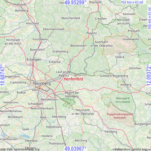
Henfenfeld GPS coordinates[2]
49° 29' 54.456" North, 11° 23' 26.124" East
| Map corner | latitude | longitude |
|---|---|---|
| Upper-left | 49.95299°, | 10.68747° |
| Center: | 49.49846°, | 11.39059° |
| Lower-right: | 49.03967°, | 12.09372° |
| Map W x H: | 101.6×101.5 km | = 63.1×63.1mi |
| max Lat: | 55.01917° ⇑75.8% North |
| Henfenfeld: | 49.49846° |
| min Lat: | ⇓24.2% South 47.40724° |
| min Long | Henfenfeld | max Long |
| 5.92978° | 11.39059° | 14.98853° |
| W 72.6%⇐ | ⇒27.4% E |
Elevation
Elevation of Henfenfeld is 341 m = 1119 ft, and this is 91.9 m = 302 ft above average elevation for this country.
| Max E: |
1256 m = 4121 ft | 32.3% |
| Henfenfeld | 341 m 1119 ft | |
| Avg. | 249.1 m = 817 ft | |
Min E: |
-5 m = -16 ft | 67.7% |
See also: Germany elevation on elevation.city.
Geographical zone
Henfenfeld is located in North temperate zone (between Tropic of Cancer and the Arctic Circle). Distance of this North polar circle is 1897.5 km =1179.1 mi to North.| Distance of | km | miles | from Henfenfeld |
|---|---|---|---|
| North Pole | 4503.3 | 2798.2 | to North |
| Arctic Circle | 1897.5 | 1179.1 | to North |
| Tropic Cancer | 2897.8 | 1800.6 | to South |
| Equator | 5503.7 | 3419.8 | to South |


Nearby cities:
15 places around Henfenfeld: (largest is in red/bold)
• Engelthal
3 km =1.9 mi,  167°
167°
• Happurg
5.8 km =3.6 mi,  95°
95°
• Hersbruck
3.3 km =2.1 mi,  65°
65°
• Kirchensittenbach
6.8 km =4.2 mi,  19°
19°
• Lauf an der Pegnitz
8 km =5 mi,  282°
282°
• Leinburg
7.8 km =4.8 mi,  228°
228°
• Neunkirchen am Sand
5.9 km =3.7 mi,  299°
299°
• Offenhausen
5.7 km =3.5 mi,  163°
163°
• Ottensoos
3.7 km =2.3 mi,  289°
289°
• Pommelsbrunn
8.7 km =5.4 mi,  85°
85°
• Reichenschwand
2.1 km =1.3 mi,  322°
322°
• Röthenbach an der Pegnitz
10.9 km =6.8 mi,  260°
260°
• Rückersdorf
10.3 km =6.4 mi,  269°
269°
• Schnaittach
7.6 km =4.7 mi,  333°
333°
• Vorra
9.9 km =6.2 mi,  48°
48°
Sources, notices
• [Note1] Compared only with cities in Germany existing in our database
• [Src1] Map data: © OpenStreetMap contributors (CC-BY-SA)
• [Src2] Other city data from geonames.org with taken over terms of usage.
• [Src3] Geographical zone / Annual Mean Temperature by Robert A. Rohde @ Wikipedia
