Alfeld geodata
Alfeld (Bavaria) is a seat of a fourth-order administrative division; located in Germany in Europe/Berlin (GMT+2) time zone. With population of 1,168 people, there are 6653 cities with bigger population in this country. Compared to other cities in Germany, 76.8% of cities are located further ↑North; 75% of cities are located further ←West and 86.4% of cities have lower elevation than Alfeld. Note1
Administrative division(s):
- Level 1: Bavaria
- Level 2: Regierungsbezirk Mittelfranken
- Level 3: Nürnberger Land
- Level 4: Alfeld


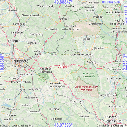
Alfeld GPS coordinates[2]
49° 25' 59.988" North, 11° 33' 0" East
| Map corner | latitude | longitude |
|---|---|---|
| Upper-left | 49.88847°, | 10.84688° |
| Center: | 49.43333°, | 11.55° |
| Lower-right: | 48.97393°, | 12.25313° |
| Map W x H: | 101.7×101.7 km | = 63.2×63.2mi |
| max Lat: | 55.01917° ⇑76.8% North |
| Alfeld: | 49.43333° |
| min Lat: | ⇓23.2% South 47.40724° |
| min Long | Alfeld | max Long |
| 5.92978° | 11.55° | 14.98853° |
| W 75%⇐ | ⇒25% E |
Elevation
Elevation of Alfeld is 481 m = 1578 ft, and this is 231.9 m = 761 ft above average elevation for this country.
| Max E: |
1256 m = 4121 ft | 13.6% |
| Alfeld | 481 m 1578 ft | |
| Avg. | 249.1 m = 817 ft | |
Min E: |
-5 m = -16 ft | 86.4% |
See also: Germany elevation on elevation.city.
Geographical zone
Alfeld is located in North temperate zone (between Tropic of Cancer and the Arctic Circle). Distance of this North polar circle is 1904.7 km =1183.5 mi to North.| Distance of | km | miles | from Alfeld |
|---|---|---|---|
| North Pole | 4510.6 | 2802.8 | to North |
| Arctic Circle | 1904.7 | 1183.5 | to North |
| Tropic Cancer | 2890.6 | 1796.1 | to South |
| Equator | 5496.5 | 3415.4 | to South |


Nearby cities:
15 places around Alfeld: (largest is in red/bold)
• Berg bei Neumarkt in der Oberpfalz
13.9 km =8.6 mi,  215°
215°
• Engelthal
11.7 km =7.3 mi,  291°
291°
• Etzelwang
10.8 km =6.7 mi,  13°
13°
• Happurg
8.8 km =5.5 mi,  319°
319°
• Henfenfeld
13.6 km =8.5 mi,  302°
302°
• Hersbruck
12.1 km =7.5 mi, 315°
• Hirschbach
13 km =8.1 mi,  354°
354°
• Illschwang
9.8 km =6.1 mi,  79°
79°
• Kastl
11.9 km =7.4 mi,  126°
126°
• Lauterhofen
8.2 km =5.1 mi,  152°
152°
• Offenhausen
10.1 km =6.3 mi,  280°
280°
• Pilsach
12.9 km =8 mi,  195°
195°
• Pommelsbrunn
8.4 km =5.2 mi,  340°
340°
• Stöckelsberg
9.8 km =6.1 mi,  236°
236°
• Weigendorf
7.3 km =4.5 mi, 10°
Sources, notices
• [Note1] Compared only with cities in Germany existing in our database
• [Src1] Map data: © OpenStreetMap contributors (CC-BY-SA)
• [Src2] Other city data from geonames.org with taken over terms of usage.
• [Src3] Geographical zone / Annual Mean Temperature by Robert A. Rohde @ Wikipedia
