Steinheim geodata
Steinheim (Hesse) is a populated place; located in Germany in Europe/Berlin (GMT+2) time zone. With population of 651 people, there are 8551 cities with bigger population in this country. Compared to other cities in Germany, 53.8% of cities are located further ↑North; 66.4% of cities are located further →East and 61.9% of cities have higher elevation than Steinheim. Note1
Administrative division(s):
- Level 1: Hesse
- Level 2: Regierungsbezirk Gießen
- Level 3: Landkreis Gießen
- Level 4: Hungen


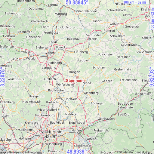
Steinheim GPS coordinates[2]
50° 26' 37.644" North, 8° 55' 26.04" East
| Map corner | latitude | longitude |
|---|---|---|
| Upper-left | 50.88945°, | 8.22078° |
| Center: | 50.44379°, | 8.9239° |
| Lower-right: | 49.9939°, | 9.62703° |
| Map W x H: | 99.6×99.6 km | = 61.9×61.9mi |
| max Lat: | 55.01917° ⇑53.8% North |
| Steinheim: | 50.44379° |
| min Lat: | ⇓46.2% South 47.40724° |
| min Long | Steinheim | max Long |
| 5.92978° | 8.9239° | 14.98853° |
| W 33.6%⇐ | ⇒66.4% E |
Elevation
Elevation of Steinheim is 139 m = 456 ft, and this is 110.1 m = 361 ft below average elevation for this country.
| Max E: |
1256 m = 4121 ft | 61.9% |
| Avg. | 249.1 m = 817 ft | |
| Steinheim | 139 m = 456 ft | |
Min E: |
-5 m = -16 ft | 38.1% |
See also: Germany elevation on elevation.city.
Geographical zone
Steinheim is located in North temperate zone (between Tropic of Cancer and the Arctic Circle). Distance of this North polar circle is 1792.4 km =1113.7 mi to North.| Distance of | km | miles | from Steinheim |
|---|---|---|---|
| North Pole | 4398.2 | 2732.9 | to North |
| Arctic Circle | 1792.4 | 1113.7 | to North |
| Tropic Cancer | 3002.9 | 1865.9 | to South |
| Equator | 5608.8 | 3485.1 | to South |


Nearby cities:
15 places around Steinheim: (largest is in red/bold)
• Berstadt
4.5 km =2.8 mi,  244°
244°
• Echzell
6.7 km =4.2 mi,  203°
203°
• Hungen
4 km =2.5 mi,  326°
326°
• Laubach
11.9 km =7.4 mi,  23°
23°
• Lich
11.5 km =7.1 mi,  318°
318°
• Melbach
10.9 km =6.8 mi,  228°
228°
• Münzenberg
10.6 km =6.6 mi,  275°
275°
• Nidda
6.8 km =4.2 mi,  120°
120°
• Ortenberg
13.5 km =8.4 mi,  136°
136°
• Ranstadt
10.5 km =6.5 mi,  156°
156°
• Reichelsheim
10.3 km =6.4 mi, 199°
• Rockenberg
13.3 km =8.3 mi,  263°
263°
• Södel
10.1 km =6.3 mi, 236°
• Wohnbach
6.9 km =4.3 mi, 255°
• Wölfersheim
9 km =5.6 mi, 237°
Sources, notices
• [Note1] Compared only with cities in Germany existing in our database
• [Src1] Map data: © OpenStreetMap contributors (CC-BY-SA)
• [Src2] Other city data from geonames.org with taken over terms of usage.
• [Src3] Geographical zone / Annual Mean Temperature by Robert A. Rohde @ Wikipedia
