Lich geodata
Lich (Hesse) is a populated place; located in Germany in Europe/Berlin (GMT+2) time zone. With population of 13,534 people, there are 1183 cities with bigger population in this country. Compared to other cities in Germany, 52.3% of cities are located further ↑North; 67.7% of cities are located further →East and 56.1% of cities have higher elevation than Lich. Note1
Administrative division(s):
- Level 1: Hesse
- Level 2: Regierungsbezirk Gießen
- Level 3: Landkreis Gießen
- Level 4: Lich


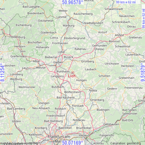
Lich GPS coordinates[2]
50° 31' 15.06" North, 8° 48' 56.412" East
| Map corner | latitude | longitude |
|---|---|---|
| Upper-left | 50.96578°, | 8.11254° |
| Center: | 50.52085°, | 8.81567° |
| Lower-right: | 50.07169°, | 9.51879° |
| Map W x H: | 99.4×99.4 km | = 61.8×61.8mi |
| max Lat: | 55.01917° ⇑52.3% North |
| Lich: | 50.52085° |
| min Lat: | ⇓47.7% South 47.40724° |
| min Long | Lich | max Long |
| 5.92978° | 8.81567° | 14.98853° |
| W 32.3%⇐ | ⇒67.7% E |
Elevation
Elevation of Lich is 181 m = 594 ft, and this is 68.1 m = 223 ft below average elevation for this country.
| Max E: |
1256 m = 4121 ft | 56.1% |
| Avg. | 249.1 m = 817 ft | |
| Lich | 181 m = 594 ft | |
Min E: |
-5 m = -16 ft | 43.9% |
See also: Germany elevation on elevation.city.
Geographical zone
Lich is located in North temperate zone (between Tropic of Cancer and the Arctic Circle). Distance of this North polar circle is 1783.8 km =1108.4 mi to North.| Distance of | km | miles | from Lich |
|---|---|---|---|
| North Pole | 4389.7 | 2727.6 | to North |
| Arctic Circle | 1783.8 | 1108.4 | to North |
| Tropic Cancer | 3011.5 | 1871.3 | to South |
| Equator | 5617.4 | 3490.5 | to South |


Nearby cities:
15 places around Lich: (largest is in red/bold)
• Alten Buseck
12.1 km =7.5 mi,  338°
338°
• Berstadt
11.1 km =6.9 mi,  161°
161°
• Beuern
11.9 km =7.4 mi,  1°
1°
• Gießen
12.4 km =7.7 mi,  306°
306°
• Großen Buseck
9.6 km =6 mi,  347°
347°
• Grünberg
13 km =8.1 mi,  51°
51°
• Hungen
7.6 km =4.7 mi,  133°
133°
• Langgöns
10.8 km =6.7 mi,  257°
257°
• Laubach
12.6 km =7.8 mi,  79°
79°
• Münzenberg
8 km =5 mi,  201°
201°
• Reiskirchen
8.9 km =5.5 mi,  8°
8°
• Rockenberg
11.5 km =7.1 mi,  209°
209°
• Steinheim
11.5 km =7.1 mi,  138°
138°
• Trohe
10.9 km =6.8 mi, 335°
• Wohnbach
10.3 km =6.4 mi,  174°
174°
Sources, notices
• [Note1] Compared only with cities in Germany existing in our database
• [Src1] Map data: © OpenStreetMap contributors (CC-BY-SA)
• [Src2] Other city data from geonames.org with taken over terms of usage.
• [Src3] Geographical zone / Annual Mean Temperature by Robert A. Rohde @ Wikipedia
