Laubach geodata
Laubach (Hesse) is a populated place; located in Germany in Europe/Berlin (GMT+2) time zone. With population of 10,205 people, there are 1602 cities with bigger population in this country. Compared to other cities in Germany, 51.9% of cities are located further ↑North; 65.6% of cities are located further →East and 52.3% of cities have higher elevation than Laubach. Note1
Administrative division(s):
- Level 1: Hesse
- Level 2: Regierungsbezirk Gießen
- Level 3: Landkreis Gießen
- Level 4: Laubach


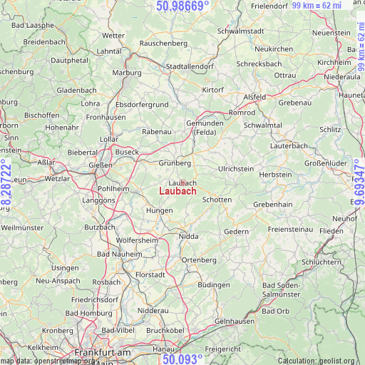
Laubach GPS coordinates[2]
50° 32' 31.056" North, 8° 59' 25.224" East
| Map corner | latitude | longitude |
|---|---|---|
| Upper-left | 50.98669°, | 8.28722° |
| Center: | 50.54196°, | 8.99034° |
| Lower-right: | 50.093°, | 9.69347° |
| Map W x H: | 99.4×99.4 km | = 61.8×61.8mi |
| max Lat: | 55.01917° ⇑51.9% North |
| Laubach: | 50.54196° |
| min Lat: | ⇓48.1% South 47.40724° |
| min Long | Laubach | max Long |
| 5.92978° | 8.99034° | 14.98853° |
| W 34.4%⇐ | ⇒65.6% E |
Elevation
Elevation of Laubach is 209 m = 686 ft, and this is 40.1 m = 132 ft below average elevation for this country.
| Max E: |
1256 m = 4121 ft | 52.3% |
| Avg. | 249.1 m = 817 ft | |
| Laubach | 209 m = 686 ft | |
Min E: |
-5 m = -16 ft | 47.7% |
See also: Germany elevation on elevation.city.
Geographical zone
Laubach is located in North temperate zone (between Tropic of Cancer and the Arctic Circle). Distance of this North polar circle is 1781.4 km =1106.9 mi to North.| Distance of | km | miles | from Laubach |
|---|---|---|---|
| North Pole | 4387.3 | 2726.1 | to North |
| Arctic Circle | 1781.4 | 1106.9 | to North |
| Tropic Cancer | 3013.8 | 1872.7 | to South |
| Equator | 5619.7 | 3491.9 | to South |


Nearby cities:
15 places around Laubach: (largest is in red/bold)
• Berstadt
15.6 km =9.7 mi,  214°
214°
• Beuern
15.3 km =9.5 mi,  308°
308°
• Großen Buseck
16.1 km =10 mi,  295°
295°
• Grünberg
6.2 km =3.9 mi,  338°
338°
• Hungen
10.2 km =6.3 mi,  222°
222°
• Lich
12.6 km =7.8 mi,  259°
259°
• Münzenberg
18.2 km =11.3 mi,  237°
237°
• Nidda
14.4 km =8.9 mi,  175°
175°
• Rabenau
17.5 km =10.9 mi,  329°
329°
• Reiskirchen
12.8 km =8 mi, 300°
• Schotten
10.4 km =6.5 mi,  114°
114°
• Steinheim
11.9 km =7.4 mi,  203°
203°
• Trohe
18.4 km =11.4 mi,  294°
294°
• Ulrichstein
14.8 km =9.2 mi,  75°
75°
• Wohnbach
17 km =10.6 mi, 222°
Sources, notices
• [Note1] Compared only with cities in Germany existing in our database
• [Src1] Map data: © OpenStreetMap contributors (CC-BY-SA)
• [Src2] Other city data from geonames.org with taken over terms of usage.
• [Src3] Geographical zone / Annual Mean Temperature by Robert A. Rohde @ Wikipedia
