Hungen geodata
Hungen (Hesse) is a populated place; located in Germany in Europe/Berlin (GMT+2) time zone. With population of 4,588 people, there are 2991 cities with bigger population in this country. Compared to other cities in Germany, 53.3% of cities are located further ↑North; 66.7% of cities are located further →East and 58.8% of cities have higher elevation than Hungen. Note1
Administrative division(s):
- Level 1: Hesse
- Level 2: Regierungsbezirk Gießen
- Level 3: Landkreis Gießen
- Level 4: Hungen


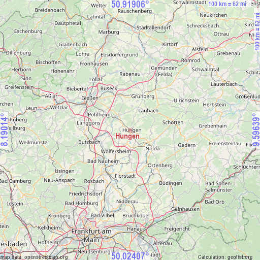
Hungen GPS coordinates[2]
50° 28' 25.248" North, 8° 53' 35.736" East
| Map corner | latitude | longitude |
|---|---|---|
| Upper-left | 50.91906°, | 8.19014° |
| Center: | 50.47368°, | 8.89326° |
| Lower-right: | 50.02407°, | 9.59639° |
| Map W x H: | 99.5×99.5 km | = 61.8×61.8mi |
| max Lat: | 55.01917° ⇑53.3% North |
| Hungen: | 50.47368° |
| min Lat: | ⇓46.7% South 47.40724° |
| min Long | Hungen | max Long |
| 5.92978° | 8.89326° | 14.98853° |
| W 33.3%⇐ | ⇒66.7% E |
Elevation
Elevation of Hungen is 162 m = 531 ft, and this is 87.1 m = 286 ft below average elevation for this country.
| Max E: |
1256 m = 4121 ft | 58.8% |
| Avg. | 249.1 m = 817 ft | |
| Hungen | 162 m = 531 ft | |
Min E: |
-5 m = -16 ft | 41.2% |
See also: Germany elevation on elevation.city.
Geographical zone
Hungen is located in North temperate zone (between Tropic of Cancer and the Arctic Circle). Distance of this North polar circle is 1789 km =1111.6 mi to North.| Distance of | km | miles | from Hungen |
|---|---|---|---|
| North Pole | 4394.9 | 2730.9 | to North |
| Arctic Circle | 1789 | 1111.6 | to North |
| Tropic Cancer | 3006.2 | 1868 | to South |
| Equator | 5612.1 | 3487.2 | to South |


Nearby cities:
15 places around Hungen: (largest is in red/bold)
• Berstadt
5.6 km =3.5 mi,  199°
199°
• Echzell
9.4 km =5.8 mi,  183°
183°
• Grünberg
14.2 km =8.8 mi,  19°
19°
• Laubach
10.2 km =6.3 mi,  42°
42°
• Lich
7.6 km =4.7 mi,  313°
313°
• Melbach
12.1 km =7.5 mi,  209°
209°
• Münzenberg
8.7 km =5.4 mi,  255°
255°
• Nidda
10.5 km =6.5 mi,  129°
129°
• Ranstadt
14.4 km =8.9 mi,  153°
153°
• Reichelsheim
13.1 km =8.1 mi,  185°
185°
• Rockenberg
12.1 km =7.5 mi,  246°
246°
• Steinheim
4 km =2.5 mi, 146°
• Södel
10.9 km =6.8 mi,  215°
215°
• Wohnbach
6.8 km =4.2 mi, 222°
• Wölfersheim
9.8 km =6.1 mi, 213°
Sources, notices
• [Note1] Compared only with cities in Germany existing in our database
• [Src1] Map data: © OpenStreetMap contributors (CC-BY-SA)
• [Src2] Other city data from geonames.org with taken over terms of usage.
• [Src3] Geographical zone / Annual Mean Temperature by Robert A. Rohde @ Wikipedia
