Heuerßen geodata
Heuerßen (Lower Saxony) is a seat of a fourth-order administrative division; located in Germany in Europe/Berlin (GMT+2) time zone. With population of 1,063 people, there are 6955 cities with bigger population in this country. Compared to other cities in Germany, 75.5% of cities are located further ↓South; 61% of cities are located further →East and 68.8% of cities have higher elevation than Heuerßen. Note1


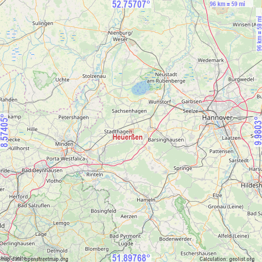
Heuerßen GPS coordinates[2]
52° 19' 46.056" North, 9° 16' 37.848" East
| Map corner | latitude | longitude |
|---|---|---|
| Upper-left | 52.75707°, | 8.57405° |
| Center: | 52.32946°, | 9.27718° |
| Lower-right: | 51.89768°, | 9.9803° |
| Map W x H: | 95.6×95.6 km | = 59.4×59.4mi |
| max Lat: | 55.01917° ⇑24.5% North |
| Heuerßen: | 52.32946° |
| min Lat: | ⇓75.5% South 47.40724° |
| min Long | Heuerßen | max Long |
| 5.92978° | 9.27718° | 14.98853° |
| W 39%⇐ | ⇒61% E |
Elevation
Elevation of Heuerßen is 98 m = 322 ft, and this is 151.1 m = 496 ft below average elevation for this country.
| Max E: |
1256 m = 4121 ft | 68.8% |
| Avg. | 249.1 m = 817 ft | |
| Heuerßen | 98 m = 322 ft | |
Min E: |
-5 m = -16 ft | 31.2% |
See also: Germany elevation on elevation.city.
Geographical zone
Heuerßen is located in North temperate zone (between Tropic of Cancer and the Arctic Circle). Distance of this North polar circle is 1582.7 km =983.4 mi to North.| Distance of | km | miles | from Heuerßen |
|---|---|---|---|
| North Pole | 4188.6 | 2602.7 | to North |
| Arctic Circle | 1582.7 | 983.4 | to North |
| Tropic Cancer | 3212.6 | 1996.2 | to South |
| Equator | 5818.5 | 3615.4 | to South |


Nearby cities:
15 places around Heuerßen: (largest is in red/bold)
• Apelern
5.9 km =3.7 mi,  137°
137°
• Auhagen
7.7 km =4.8 mi,  7°
7°
• Bad Nenndorf
7 km =4.3 mi,  83°
83°
• Beckedorf
3.5 km =2.2 mi,  49°
49°
• Hohnhorst
7.8 km =4.8 mi,  55°
55°
• Lauenhagen
5.6 km =3.5 mi,  301°
301°
• Lindhorst
3.2 km =2 mi, 7°
• Lüdersfeld
3.7 km =2.3 mi,  335°
335°
• Meerbeck
8.7 km =5.4 mi,  279°
279°
• Nienstädt
8.7 km =5.4 mi,  241°
241°
• Nordsehl
6.8 km =4.2 mi,  289°
289°
• Pohle
8.4 km =5.2 mi,  147°
147°
• Rodenberg
5.7 km =3.5 mi,  110°
110°
• Sachsenhagen
7.6 km =4.7 mi,  355°
355°
• Stadthagen
5.1 km =3.2 mi,  262°
262°
Sources, notices
• [Note1] Compared only with cities in Germany existing in our database
• [Src1] Map data: © OpenStreetMap contributors (CC-BY-SA)
• [Src2] Other city data from geonames.org with taken over terms of usage.
• [Src3] Geographical zone / Annual Mean Temperature by Robert A. Rohde @ Wikipedia
