Lüdersfeld geodata
Lüdersfeld (Lower Saxony) is a seat of a fourth-order administrative division; located in Germany in Europe/Berlin (GMT+2) time zone. With population of 1,078 people, there are 6918 cities with bigger population in this country. Compared to other cities in Germany, 75.8% of cities are located further ↓South; 61.4% of cities are located further →East and 77.3% of cities have higher elevation than Lüdersfeld. Note1


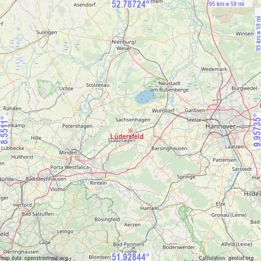
Lüdersfeld GPS coordinates[2]
52° 21' 35.748" North, 9° 15' 15.192" East
| Map corner | latitude | longitude |
|---|---|---|
| Upper-left | 52.78724°, | 8.5511° |
| Center: | 52.35993°, | 9.25422° |
| Lower-right: | 51.92844°, | 9.95735° |
| Map W x H: | 95.5×95.5 km | = 59.3×59.3mi |
| max Lat: | 55.01917° ⇑24.2% North |
| Lüdersfeld: | 52.35993° |
| min Lat: | ⇓75.8% South 47.40724° |
| min Long | Lüdersfeld | max Long |
| 5.92978° | 9.25422° | 14.98853° |
| W 38.6%⇐ | ⇒61.4% E |
Elevation
Elevation of Lüdersfeld is 55 m = 180 ft, and this is 194.1 m = 637 ft below average elevation for this country.
| Max E: |
1256 m = 4121 ft | 77.3% |
| Avg. | 249.1 m = 817 ft | |
| Lüdersfeld | 55 m = 180 ft | |
Min E: |
-5 m = -16 ft | 22.7% |
See also: Germany elevation on elevation.city.
Geographical zone
Lüdersfeld is located in North temperate zone (between Tropic of Cancer and the Arctic Circle). Distance of this North polar circle is 1579.3 km =981.3 mi to North.| Distance of | km | miles | from Lüdersfeld |
|---|---|---|---|
| North Pole | 4185.2 | 2600.6 | to North |
| Arctic Circle | 1579.3 | 981.3 | to North |
| Tropic Cancer | 3216 | 1998.3 | to South |
| Equator | 5821.9 | 3617.6 | to South |


Nearby cities:
15 places around Lüdersfeld: (largest is in red/bold)
• Auhagen
5 km =3.1 mi,  30°
30°
• Bad Nenndorf
8.9 km =5.5 mi,  106°
106°
• Beckedorf
4.4 km =2.7 mi,  104°
104°
• Heuerßen
3.7 km =2.3 mi,  155°
155°
• Hohnhorst
8 km =5 mi,  82°
82°
• Lauenhagen
3.3 km =2.1 mi,  261°
261°
• Lindhorst
2 km =1.2 mi, 96°
• Meerbeck
7.3 km =4.5 mi,  253°
253°
• Niedernwöhren
7.3 km =4.5 mi, 263°
• Nordsehl
4.9 km =3 mi, 257°
• Pollhagen
5.3 km =3.3 mi,  302°
302°
• Rodenberg
8.8 km =5.5 mi,  127°
127°
• Sachsenhagen
4.3 km =2.7 mi,  12°
12°
• Stadthagen
5.3 km =3.3 mi,  220°
220°
• Wölpinghausen
6.5 km =4 mi,  347°
347°
Sources, notices
• [Note1] Compared only with cities in Germany existing in our database
• [Src1] Map data: © OpenStreetMap contributors (CC-BY-SA)
• [Src2] Other city data from geonames.org with taken over terms of usage.
• [Src3] Geographical zone / Annual Mean Temperature by Robert A. Rohde @ Wikipedia
