Hörselgau geodata
Hörselgau (Thuringia) is a populated place; located in Germany in Europe/Berlin (GMT+2) time zone. With population of 1,311 people, there are 6275 cities with bigger population in this country. Compared to other cities in Germany, 56.6% of cities are located further ↓South; 60.5% of cities are located further ←West and 61.9% of cities have lower elevation than Hörselgau. Note1


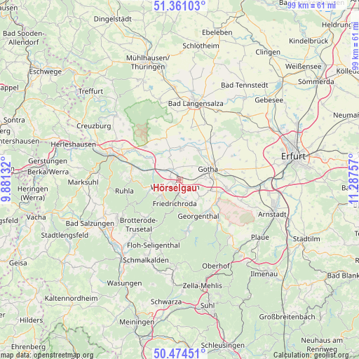
Hörselgau GPS coordinates[2]
50° 55' 11.568" North, 10° 35' 3.984" East
| Map corner | latitude | longitude |
|---|---|---|
| Upper-left | 51.36103°, | 9.88132° |
| Center: | 50.91988°, | 10.58444° |
| Lower-right: | 50.47451°, | 11.28757° |
| Map W x H: | 98.6×98.6 km | = 61.3×61.3mi |
| max Lat: | 55.01917° ⇑43.4% North |
| Hörselgau: | 50.91988° |
| min Lat: | ⇓56.6% South 47.40724° |
| min Long | Hörselgau | max Long |
| 5.92978° | 10.58444° | 14.98853° |
| W 60.5%⇐ | ⇒39.5% E |
Elevation
Elevation of Hörselgau is 301 m = 988 ft, and this is 51.9 m = 170 ft above average elevation for this country.
| Max E: |
1256 m = 4121 ft | 38.1% |
| Hörselgau | 301 m 988 ft | |
| Avg. | 249.1 m = 817 ft | |
Min E: |
-5 m = -16 ft | 61.9% |
See also: Germany elevation on elevation.city.
Geographical zone
Hörselgau is located in North temperate zone (between Tropic of Cancer and the Arctic Circle). Distance of this North polar circle is 1739.4 km =1080.8 mi to North.| Distance of | km | miles | from Hörselgau |
|---|---|---|---|
| North Pole | 4345.3 | 2700 | to North |
| Arctic Circle | 1739.4 | 1080.8 | to North |
| Tropic Cancer | 3055.8 | 1898.8 | to South |
| Equator | 5661.8 | 3518.1 | to South |


Nearby cities:
15 places around Hörselgau: (largest is in red/bold)
• Brüheim
8.9 km =5.5 mi,  359°
359°
• Emleben
8.8 km =5.5 mi,  109°
109°
• Ernstroda
6.6 km =4.1 mi,  157°
157°
• Finsterbergen
9.5 km =5.9 mi,  177°
177°
• Friedrichroda
7.1 km =4.4 mi,  191°
191°
• Friedrichswerth
8.7 km =5.4 mi,  341°
341°
• Goldbach
9.6 km =6 mi,  32°
32°
• Gotha
8.8 km =5.5 mi,  69°
69°
• Haina
9.1 km =5.7 mi,  328°
328°
• Laucha
3 km =1.9 mi,  282°
282°
• Mechterstädt
4.9 km =3 mi,  300°
300°
• Remstädt
9.8 km =6.1 mi,  47°
47°
• Sonneborn
8.1 km =5 mi,  3°
3°
• Tabarz
6.9 km =4.3 mi,  224°
224°
• Waltershausen
3 km =1.9 mi, 217°
Sources, notices
• [Note1] Compared only with cities in Germany existing in our database
• [Src1] Map data: © OpenStreetMap contributors (CC-BY-SA)
• [Src2] Other city data from geonames.org with taken over terms of usage.
• [Src3] Geographical zone / Annual Mean Temperature by Robert A. Rohde @ Wikipedia
