Laucha geodata
Laucha (Thuringia) is a populated place; located in Germany in Europe/Berlin (GMT+2) time zone. With population of 533 people, there are 9177 cities with bigger population in this country. Compared to other cities in Germany, 56.7% of cities are located further ↓South; 59.7% of cities are located further ←West and 62.1% of cities have lower elevation than Laucha. Note1


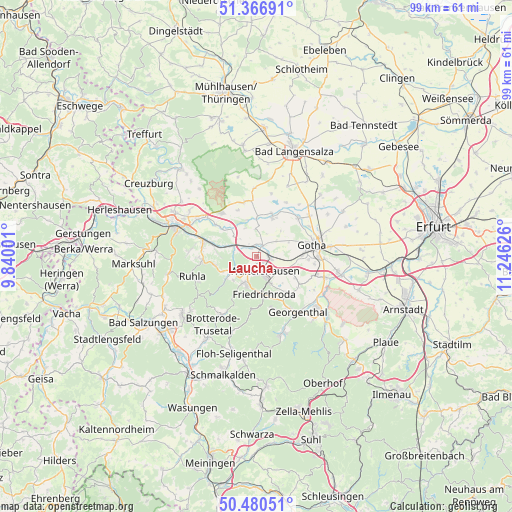
Laucha GPS coordinates[2]
50° 55' 32.952" North, 10° 32' 35.268" East
| Map corner | latitude | longitude |
|---|---|---|
| Upper-left | 51.36691°, | 9.84001° |
| Center: | 50.92582°, | 10.54313° |
| Lower-right: | 50.48051°, | 11.24626° |
| Map W x H: | 98.6×98.6 km | = 61.3×61.3mi |
| max Lat: | 55.01917° ⇑43.3% North |
| Laucha: | 50.92582° |
| min Lat: | ⇓56.7% South 47.40724° |
| min Long | Laucha | max Long |
| 5.92978° | 10.54313° | 14.98853° |
| W 59.7%⇐ | ⇒40.3% E |
Elevation
Elevation of Laucha is 302 m = 991 ft, and this is 52.9 m = 174 ft above average elevation for this country.
| Max E: |
1256 m = 4121 ft | 37.9% |
| Laucha | 302 m 991 ft | |
| Avg. | 249.1 m = 817 ft | |
Min E: |
-5 m = -16 ft | 62.1% |
See also: Germany elevation on elevation.city.
Geographical zone
Laucha is located in North temperate zone (between Tropic of Cancer and the Arctic Circle). Distance of this North polar circle is 1738.8 km =1080.4 mi to North.| Distance of | km | miles | from Laucha |
|---|---|---|---|
| North Pole | 4344.6 | 2699.6 | to North |
| Arctic Circle | 1738.8 | 1080.4 | to North |
| Tropic Cancer | 3056.5 | 1899.2 | to South |
| Equator | 5662.4 | 3518.5 | to South |


Nearby cities:
15 places around Laucha: (largest is in red/bold)
• Brüheim
8.7 km =5.4 mi,  18°
18°
• Ernstroda
8.7 km =5.4 mi,  141°
141°
• Finsterbergen
10.6 km =6.6 mi,  162°
162°
• Friedrichroda
7.7 km =4.8 mi,  168°
168°
• Friedrichswerth
7.6 km =4.7 mi,  0°
0°
• Goldbach
10.9 km =6.8 mi,  47°
47°
• Gotha
11.4 km =7.1 mi,  77°
77°
• Haina
7.3 km =4.5 mi,  345°
345°
• Hörselgau
3 km =1.9 mi,  102°
102°
• Mechterstädt
2.3 km =1.4 mi,  323°
323°
• Seebach
8.9 km =5.5 mi,  263°
263°
• Sonneborn
8.2 km =5.1 mi, 24°
• Tabarz
5.9 km =3.7 mi,  198°
198°
• Thal
10.6 km =6.6 mi, 264°
• Waltershausen
3.2 km =2 mi, 161°
Sources, notices
• [Note1] Compared only with cities in Germany existing in our database
• [Src1] Map data: © OpenStreetMap contributors (CC-BY-SA)
• [Src2] Other city data from geonames.org with taken over terms of usage.
• [Src3] Geographical zone / Annual Mean Temperature by Robert A. Rohde @ Wikipedia
