Solpke geodata
Solpke (Saxony-Anhalt) is a populated place; located in Germany in Europe/Berlin (GMT+2) time zone. With population of 623 people, there are 8698 cities with bigger population in this country. Compared to other cities in Germany, 77.5% of cities are located further ↓South; 71.1% of cities are located further ←West and 75% of cities have higher elevation than Solpke. Note1
Administrative division(s):
- Level 1: Saxony-Anhalt
- Level 3: Altmarkkreis Salzwedel
- Level 4: Gardelegen


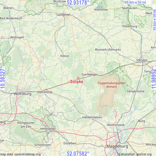
Solpke GPS coordinates[2]
52° 30' 21.168" North, 11° 17' 11.004" East
| Map corner | latitude | longitude |
|---|---|---|
| Upper-left | 52.93178°, | 10.58327° |
| Center: | 52.50588°, | 11.28639° |
| Lower-right: | 52.07582°, | 11.98952° |
| Map W x H: | 95.2×95.2 km | = 59.2×59.2mi |
| max Lat: | 55.01917° ⇑22.5% North |
| Solpke: | 52.50588° |
| min Lat: | ⇓77.5% South 47.40724° |
| min Long | Solpke | max Long |
| 5.92978° | 11.28639° | 14.98853° |
| W 71.1%⇐ | ⇒28.9% E |
Elevation
Elevation of Solpke is 63 m = 207 ft, and this is 186.1 m = 611 ft below average elevation for this country.
| Max E: |
1256 m = 4121 ft | 75% |
| Avg. | 249.1 m = 817 ft | |
| Solpke | 63 m = 207 ft | |
Min E: |
-5 m = -16 ft | 25% |
See also: Germany elevation on elevation.city.
Geographical zone
Solpke is located in North temperate zone (between Tropic of Cancer and the Arctic Circle). Distance of this North polar circle is 1563.1 km =971.3 mi to North.| Distance of | km | miles | from Solpke |
|---|---|---|---|
| North Pole | 4169 | 2590.5 | to North |
| Arctic Circle | 1563.1 | 971.3 | to North |
| Tropic Cancer | 3232.2 | 2008.4 | to South |
| Equator | 5838.1 | 3627.6 | to South |


Nearby cities:
15 places around Solpke: (largest is in red/bold)
• Berge
7.6 km =4.7 mi,  47°
47°
• Calvörde
12.3 km =7.6 mi,  177°
177°
• Engersen
13.2 km =8.2 mi,  16°
16°
• Etingen
14.7 km =9.1 mi,  212°
212°
• Gardelegen
7.7 km =4.8 mi,  73°
73°
• Jävenitz
14.5 km =9 mi,  81°
81°
• Kalbe
18 km =11.2 mi, 21°
• Kloster Neuendorf
12.2 km =7.6 mi, 79°
• Klötze
15.8 km =9.8 mi,  328°
328°
• Kusey
15.6 km =9.7 mi,  301°
301°
• Letzlingen
15 km =9.3 mi,  116°
116°
• Mieste
6 km =3.7 mi,  244°
244°
• Miesterhorst
11.1 km =6.9 mi, 242°
• Rätzlingen
16.5 km =10.3 mi,  225°
225°
• Wenze
12.2 km =7.6 mi, 302°
Sources, notices
• [Note1] Compared only with cities in Germany existing in our database
• [Src1] Map data: © OpenStreetMap contributors (CC-BY-SA)
• [Src2] Other city data from geonames.org with taken over terms of usage.
• [Src3] Geographical zone / Annual Mean Temperature by Robert A. Rohde @ Wikipedia
