Etingen geodata
Etingen (Saxony-Anhalt) is a populated place; located in Germany in Europe/Berlin (GMT+2) time zone. With population of 517 people, there are 9276 cities with bigger population in this country. Compared to other cities in Germany, 76.1% of cities are located further ↓South; 69.5% of cities are located further ←West and 71% of cities have higher elevation than Etingen. Note1


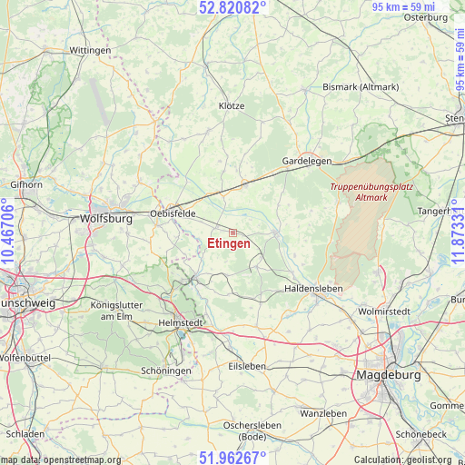
Etingen GPS coordinates[2]
52° 23' 37.788" North, 11° 10' 12.648" East
| Map corner | latitude | longitude |
|---|---|---|
| Upper-left | 52.82082°, | 10.46706° |
| Center: | 52.39383°, | 11.17018° |
| Lower-right: | 51.96267°, | 11.87331° |
| Map W x H: | 95.4×95.4 km | = 59.3×59.3mi |
| max Lat: | 55.01917° ⇑23.9% North |
| Etingen: | 52.39383° |
| min Lat: | ⇓76.1% South 47.40724° |
| min Long | Etingen | max Long |
| 5.92978° | 11.17018° | 14.98853° |
| W 69.5%⇐ | ⇒30.5% E |
Elevation
Elevation of Etingen is 85 m = 279 ft, and this is 164.1 m = 538 ft below average elevation for this country.
| Max E: |
1256 m = 4121 ft | 71% |
| Avg. | 249.1 m = 817 ft | |
| Etingen | 85 m = 279 ft | |
Min E: |
-5 m = -16 ft | 29% |
See also: Germany elevation on elevation.city.
Geographical zone
Etingen is located in North temperate zone (between Tropic of Cancer and the Arctic Circle). Distance of this North polar circle is 1575.5 km =979 mi to North.| Distance of | km | miles | from Etingen |
|---|---|---|---|
| North Pole | 4181.4 | 2598.2 | to North |
| Arctic Circle | 1575.5 | 979 | to North |
| Tropic Cancer | 3219.7 | 2000.6 | to South |
| Equator | 5825.6 | 3619.9 | to South |


Nearby cities:
15 places around Etingen: (largest is in red/bold)
• Bahrdorf
11.6 km =7.2 mi,  265°
265°
• Behnsdorf
8.8 km =5.5 mi,  187°
187°
• Calvörde
8.4 km =5.2 mi,  88°
88°
• Flechtingen
8.5 km =5.3 mi,  145°
145°
• Grasleben
14.4 km =8.9 mi,  227°
227°
• Hörsingen
12.8 km =8 mi,  184°
184°
• Ivenrode
14.1 km =8.8 mi,  162°
162°
• Mieste
10.1 km =6.3 mi,  14°
14°
• Miesterhorst
7.7 km =4.8 mi,  345°
345°
• Oebisfelde
13.2 km =8.2 mi,  289°
289°
• Rätzlingen
3.9 km =2.4 mi,  282°
282°
• Siestedt
9.9 km =6.2 mi,  212°
212°
• Solpke
14.7 km =9.1 mi,  32°
32°
• Walbeck
14.6 km =9.1 mi, 209°
• Weferlingen
11.9 km =7.4 mi,  219°
219°
Sources, notices
• [Note1] Compared only with cities in Germany existing in our database
• [Src1] Map data: © OpenStreetMap contributors (CC-BY-SA)
• [Src2] Other city data from geonames.org with taken over terms of usage.
• [Src3] Geographical zone / Annual Mean Temperature by Robert A. Rohde @ Wikipedia
