Calvörde geodata
Calvörde (Saxony-Anhalt) is a seat of a fourth-order administrative division; located in Germany in Europe/Berlin (GMT+2) time zone. With population of 1,742 people, there are 5436 cities with bigger population in this country. Compared to other cities in Germany, 76.1% of cities are located further ↓South; 71.2% of cities are located further ←West and 76.1% of cities have higher elevation than Calvörde. Note1


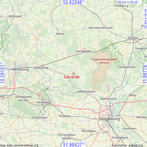
Calvörde GPS coordinates[2]
52° 23' 43.836" North, 11° 17' 40.668" East
| Map corner | latitude | longitude |
|---|---|---|
| Upper-left | 52.82248°, | 10.59151° |
| Center: | 52.39551°, | 11.29463° |
| Lower-right: | 51.96437°, | 11.99776° |
| Map W x H: | 95.4×95.4 km | = 59.3×59.3mi |
| max Lat: | 55.01917° ⇑23.9% North |
| Calvörde: | 52.39551° |
| min Lat: | ⇓76.1% South 47.40724° |
| min Long | Calvörde | max Long |
| 5.92978° | 11.29463° | 14.98853° |
| W 71.2%⇐ | ⇒28.8% E |
Elevation
Elevation of Calvörde is 59 m = 194 ft, and this is 190.1 m = 624 ft below average elevation for this country.
| Max E: |
1256 m = 4121 ft | 76.1% |
| Avg. | 249.1 m = 817 ft | |
| Calvörde | 59 m = 194 ft | |
Min E: |
-5 m = -16 ft | 23.9% |
See also: Germany elevation on elevation.city.
Geographical zone
Calvörde is located in North temperate zone (between Tropic of Cancer and the Arctic Circle). Distance of this North polar circle is 1575.3 km =978.8 mi to North.| Distance of | km | miles | from Calvörde |
|---|---|---|---|
| North Pole | 4181.2 | 2598.1 | to North |
| Arctic Circle | 1575.3 | 978.8 | to North |
| Tropic Cancer | 3219.9 | 2000.8 | to South |
| Equator | 5825.8 | 3620 | to South |


Nearby cities:
15 places around Calvörde: (largest is in red/bold)
• Altenhausen
15.1 km =9.4 mi,  190°
190°
• Behnsdorf
13.1 km =8.1 mi,  227°
227°
• Bülstringen
9.5 km =5.9 mi,  156°
156°
• Etingen
8.4 km =5.2 mi,  268°
268°
• Flechtingen
8 km =5 mi,  206°
206°
• Gardelegen
15.9 km =9.9 mi,  25°
25°
• Haldensleben I
14.2 km =8.8 mi,  146°
146°
• Ivenrode
14.3 km =8.9 mi,  197°
197°
• Letzlingen
14.1 km =8.8 mi,  66°
66°
• Mieste
11.3 km =7 mi,  328°
328°
• Miesterhorst
12.7 km =7.9 mi,  304°
304°
• Neuenhofe
15.4 km =9.6 mi,  132°
132°
• Rätzlingen
12.3 km =7.6 mi, 273°
• Solpke
12.3 km =7.6 mi,  357°
357°
• Süplingen
12.2 km =7.6 mi,  170°
170°
Sources, notices
• [Note1] Compared only with cities in Germany existing in our database
• [Src1] Map data: © OpenStreetMap contributors (CC-BY-SA)
• [Src2] Other city data from geonames.org with taken over terms of usage.
• [Src3] Geographical zone / Annual Mean Temperature by Robert A. Rohde @ Wikipedia
