Sietow geodata
Sietow (Mecklenburg-Vorpommern) is a populated place; located in Germany in Europe/Berlin (GMT+2) time zone. With population of 662 people, there are 8506 cities with bigger population in this country. Compared to other cities in Germany, 85% of cities are located further ↓South; 88.5% of cities are located further ←West and 72.4% of cities have higher elevation than Sietow. Note1
Administrative division(s):
- Level 1: Mecklenburg-Vorpommern
- Level 3: Mecklenburgische Seenplatte
- Level 4: Sietow


Sietow GPS coordinates[2]
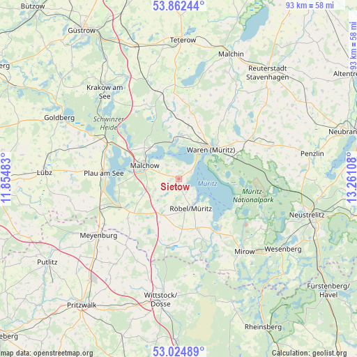
53° 26' 44.628" North, 12° 33' 28.62" East
| Map corner | latitude | longitude |
|---|---|---|
| Upper-left | 53.86244°, | 11.85483° |
| Center: | 53.44573°, | 12.55795° |
| Lower-right: | 53.02489°, | 13.26108° |
| Map W x H: | 93.1×93.1 km | = 57.8×57.8mi |
| max Lat: | 55.01917° ⇑15% North |
| Sietow: | 53.44573° |
| min Lat: | ⇓85% South 47.40724° |
| min Long | Sietow | max Long |
| 5.92978° | 12.55795° | 14.98853° |
| W 88.5%⇐ | ⇒11.5% E |
Elevation
Elevation of Sietow is 75 m = 246 ft, and this is 174.1 m = 571 ft below average elevation for this country.
| Max E: |
1256 m = 4121 ft | 72.4% |
| Avg. | 249.1 m = 817 ft | |
| Sietow | 75 m = 246 ft | |
Min E: |
-5 m = -16 ft | 27.6% |
See also: Germany elevation on elevation.city.
Geographical zone
Sietow is located in North temperate zone (between Tropic of Cancer and the Arctic Circle). Distance of this North polar circle is 1458.6 km =906.3 mi to North.| Distance of | km | miles | from Sietow |
|---|---|---|---|
| North Pole | 4064.5 | 2525.6 | to North |
| Arctic Circle | 1458.6 | 906.3 | to North |
| Tropic Cancer | 3336.7 | 2073.3 | to South |
| Equator | 5942.6 | 3692.6 | to South |


Nearby cities:
15 places around Sietow: (largest is in red/bold)
• Alt Schwerin
15.8 km =9.8 mi,  297°
297°
• Bütow
12.2 km =7.6 mi,  203°
203°
• Grabowhöfe
13.9 km =8.6 mi,  10°
10°
• Göhren-Lebbin
4.9 km =3 mi,  320°
320°
• Jabel
10.2 km =6.3 mi,  355°
355°
• Kargow
16.6 km =10.3 mi,  64°
64°
• Klink
5.5 km =3.4 mi,  49°
49°
• Malchow
9.6 km =6 mi,  289°
289°
• Nossentiner Hütte
13.2 km =8.2 mi, 318°
• Plau am See
19.6 km =12.2 mi,  274°
274°
• Rechlin
16.5 km =10.3 mi,  137°
137°
• Röbel
8.4 km =5.2 mi,  158°
158°
• Vielist
13.2 km =8.2 mi,  23°
23°
• Waren
11.6 km =7.2 mi,  44°
44°
• Wredenhagen
17.5 km =10.9 mi,  188°
188°
Sources, notices
• [Note1] Compared only with cities in Germany existing in our database
• [Src1] Map data: © OpenStreetMap contributors (CC-BY-SA)
• [Src2] Other city data from geonames.org with taken over terms of usage.
• [Src3] Geographical zone / Annual Mean Temperature by Robert A. Rohde @ Wikipedia
