Waren geodata
Waren (Mecklenburg-Vorpommern) is a populated place; located in Germany in Europe/Berlin (GMT+2) time zone. With population of 21,470 people, there are 707 cities with bigger population in this country. Compared to other cities in Germany, 85.8% of cities are located further ↓South; 89.6% of cities are located further ←West and 74.3% of cities have higher elevation than Waren. Note1
Administrative division(s):
- Level 1: Mecklenburg-Vorpommern
- Level 3: Mecklenburgische Seenplatte
- Level 4: Waren (Müritz)


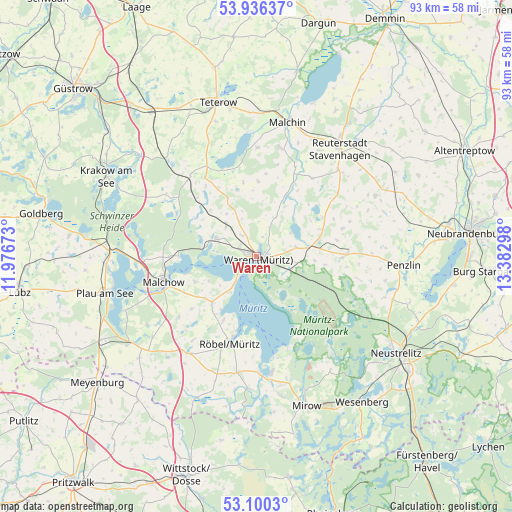
Waren GPS coordinates[2]
53° 31' 13.44" North, 12° 40' 47.46" East
| Map corner | latitude | longitude |
|---|---|---|
| Upper-left | 53.93637°, | 11.97673° |
| Center: | 53.5204°, | 12.67985° |
| Lower-right: | 53.1003°, | 13.38298° |
| Map W x H: | 93×93 km | = 57.8×57.8mi |
| max Lat: | 55.01917° ⇑14.2% North |
| Waren: | 53.5204° |
| min Lat: | ⇓85.8% South 47.40724° |
| min Long | Waren | max Long |
| 5.92978° | 12.67985° | 14.98853° |
| W 89.6%⇐ | ⇒10.4% E |
Elevation
Elevation of Waren is 66 m = 217 ft, and this is 183.1 m = 601 ft below average elevation for this country.
| Max E: |
1256 m = 4121 ft | 74.3% |
| Avg. | 249.1 m = 817 ft | |
| Waren | 66 m = 217 ft | |
Min E: |
-5 m = -16 ft | 25.7% |
See also: Germany elevation on elevation.city.
Geographical zone
Waren is located in North temperate zone (between Tropic of Cancer and the Arctic Circle). Distance of this North polar circle is 1450.3 km =901.2 mi to North.| Distance of | km | miles | from Waren |
|---|---|---|---|
| North Pole | 4056.2 | 2520.4 | to North |
| Arctic Circle | 1450.3 | 901.2 | to North |
| Tropic Cancer | 3345 | 2078.5 | to South |
| Equator | 5950.9 | 3697.7 | to South |


Nearby cities:
15 places around Waren: (largest is in red/bold)
• Dahmen
16.9 km =10.5 mi,  337°
337°
• Faulenrost
14.8 km =9.2 mi,  28°
28°
• Grabowhöfe
7.8 km =4.8 mi,  313°
313°
• Groß Gievitz
9.5 km =5.9 mi,  45°
45°
• Groß Plasten
11.7 km =7.3 mi,  75°
75°
• Göhren-Lebbin
12.1 km =7.5 mi,  247°
247°
• Jabel
9.1 km =5.7 mi,  282°
282°
• Kargow
6.9 km =4.3 mi,  99°
99°
• Klink
6.1 km =3.8 mi,  219°
219°
• Malchow
17.8 km =11.1 mi, 253°
• Möllenhagen
16.5 km =10.3 mi,  88°
88°
• Nossentiner Hütte
17 km =10.6 mi, 275°
• Röbel
16.9 km =10.5 mi,  197°
197°
• Sietow
11.6 km =7.2 mi, 224°
• Vielist
4.6 km =2.9 mi,  324°
324°
Sources, notices
• [Note1] Compared only with cities in Germany existing in our database
• [Src1] Map data: © OpenStreetMap contributors (CC-BY-SA)
• [Src2] Other city data from geonames.org with taken over terms of usage.
• [Src3] Geographical zone / Annual Mean Temperature by Robert A. Rohde @ Wikipedia
