Schwerstedt geodata
Schwerstedt (Thuringia) is a seat of a fourth-order administrative division; located in Germany in Europe/Berlin (GMT+2) time zone. With population of 695 people, there are 8341 cities with bigger population in this country. Compared to other cities in Germany, 60.9% of cities are located further ↓South; 65.8% of cities are located further ←West and 58.9% of cities have higher elevation than Schwerstedt. Note1


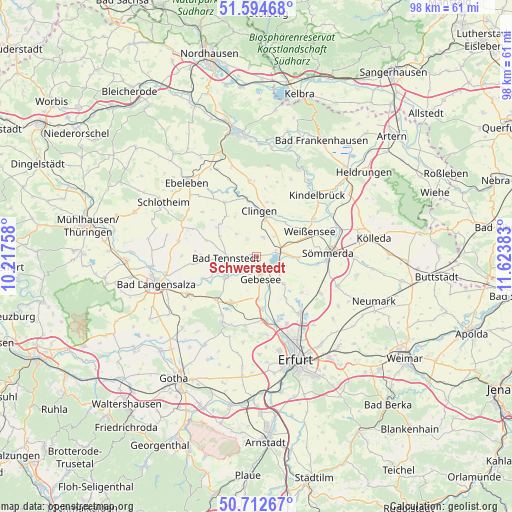
Schwerstedt GPS coordinates[2]
51° 9' 20.808" North, 10° 55' 14.52" East
| Map corner | latitude | longitude |
|---|---|---|
| Upper-left | 51.59468°, | 10.21758° |
| Center: | 51.15578°, | 10.9207° |
| Lower-right: | 50.71267°, | 11.62383° |
| Map W x H: | 98.1×98.1 km | = 61×61mi |
| max Lat: | 55.01917° ⇑39.1% North |
| Schwerstedt: | 51.15578° |
| min Lat: | ⇓60.9% South 47.40724° |
| min Long | Schwerstedt | max Long |
| 5.92978° | 10.9207° | 14.98853° |
| W 65.8%⇐ | ⇒34.2% E |
Elevation
Elevation of Schwerstedt is 161 m = 528 ft, and this is 88.1 m = 289 ft below average elevation for this country.
| Max E: |
1256 m = 4121 ft | 58.9% |
| Avg. | 249.1 m = 817 ft | |
| Schwerstedt | 161 m = 528 ft | |
Min E: |
-5 m = -16 ft | 41.1% |
See also: Germany elevation on elevation.city.
Geographical zone
Schwerstedt is located in North temperate zone (between Tropic of Cancer and the Arctic Circle). Distance of this North polar circle is 1713.2 km =1064.5 mi to North.| Distance of | km | miles | from Schwerstedt |
|---|---|---|---|
| North Pole | 4319.1 | 2683.8 | to North |
| Arctic Circle | 1713.2 | 1064.5 | to North |
| Tropic Cancer | 3082.1 | 1915.1 | to South |
| Equator | 5688 | 3534.4 | to South |


Nearby cities:
15 places around Schwerstedt: (largest is in red/bold)
• Andisleben
8.1 km =5 mi,  176°
176°
• Bad Tennstedt
5.7 km =3.5 mi,  268°
268°
• Clingen
8.5 km =5.3 mi,  5°
5°
• Gangloffsömmern
4.1 km =2.5 mi,  22°
22°
• Gebesee
4.6 km =2.9 mi,  168°
168°
• Greußen
8.4 km =5.2 mi, 11°
• Haussömmern
7.9 km =4.9 mi,  292°
292°
• Haßleben
7.4 km =4.6 mi,  134°
134°
• Henschleben
4.1 km =2.5 mi, 127°
• Herbsleben
7.5 km =4.7 mi,  234°
234°
• Herrnschwende
8.7 km =5.4 mi,  39°
39°
• Ringleben
6.5 km =4 mi,  161°
161°
• Straußfurt
4.5 km =2.8 mi,  74°
74°
• Werningshausen
5.9 km =3.7 mi,  107°
107°
• Wundersleben
8.2 km =5.1 mi,  91°
91°
Sources, notices
• [Note1] Compared only with cities in Germany existing in our database
• [Src1] Map data: © OpenStreetMap contributors (CC-BY-SA)
• [Src2] Other city data from geonames.org with taken over terms of usage.
• [Src3] Geographical zone / Annual Mean Temperature by Robert A. Rohde @ Wikipedia
