Schwarzenfeld geodata
Schwarzenfeld (Bavaria) is a populated place; located in Germany in Europe/Berlin (GMT+2) time zone. With population of 6,398 people, there are 2333 cities with bigger population in this country. Compared to other cities in Germany, 77.3% of cities are located further ↑North; 83.7% of cities are located further ←West and 70.7% of cities have lower elevation than Schwarzenfeld. Note1
Administrative division(s):
- Level 1: Bavaria
- Level 2: Upper Palatinate
- Level 3: Landkreis Schwandorf
- Level 4: Schwarzenfeld, Markt


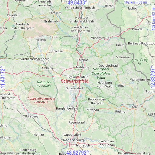
Schwarzenfeld GPS coordinates[2]
49° 23' 15.864" North, 12° 8' 5.424" East
| Map corner | latitude | longitude |
|---|---|---|
| Upper-left | 49.8433°, | 11.43172° |
| Center: | 49.38774°, | 12.13484° |
| Lower-right: | 48.92792°, | 12.83797° |
| Map W x H: | 101.8×101.8 km | = 63.3×63.3mi |
| max Lat: | 55.01917° ⇑77.3% North |
| Schwarzenfeld: | 49.38774° |
| min Lat: | ⇓22.7% South 47.40724° |
| min Long | Schwarzenfeld | max Long |
| 5.92978° | 12.13484° | 14.98853° |
| W 83.7%⇐ | ⇒16.3% E |
Elevation
Elevation of Schwarzenfeld is 364 m = 1194 ft, and this is 114.9 m = 377 ft above average elevation for this country.
| Max E: |
1256 m = 4121 ft | 29.3% |
| Schwarzenfeld | 364 m 1194 ft | |
| Avg. | 249.1 m = 817 ft | |
Min E: |
-5 m = -16 ft | 70.7% |
See also: Germany elevation on elevation.city.
Geographical zone
Schwarzenfeld is located in North temperate zone (between Tropic of Cancer and the Arctic Circle). Distance of this North polar circle is 1909.8 km =1186.7 mi to North.| Distance of | km | miles | from Schwarzenfeld |
|---|---|---|---|
| North Pole | 4515.7 | 2805.9 | to North |
| Arctic Circle | 1909.8 | 1186.7 | to North |
| Tropic Cancer | 2885.5 | 1793 | to South |
| Equator | 5491.4 | 3412.2 | to South |


Nearby cities:
15 places around Schwarzenfeld: (largest is in red/bold)
• Altendorf
10.8 km =6.7 mi,  79°
79°
• Breitenbrunn
8.7 km =5.4 mi,  252°
252°
• Ebermannsdorf
14.4 km =8.9 mi,  272°
272°
• Ensdorf
15.3 km =9.5 mi, 250°
• Freudenberg
15.3 km =9.5 mi,  314°
314°
• Guteneck
12.8 km =8 mi,  57°
57°
• Holzheim bei Oder
13.7 km =8.5 mi,  170°
170°
• Nabburg
8 km =5 mi,  24°
24°
• Pfreimd
12 km =7.5 mi, 16°
• Schmidgaden
5 km =3.1 mi,  322°
322°
• Schwandorf in Bayern
7.2 km =4.5 mi,  194°
194°
• Schwarzhofen
15.2 km =9.4 mi,  94°
94°
• Steinberg
12.1 km =7.5 mi,  163°
163°
• Stulln
3.2 km =2 mi,  358°
358°
• Wackersdorf
8.6 km =5.3 mi, 156°
Sources, notices
• [Note1] Compared only with cities in Germany existing in our database
• [Src1] Map data: © OpenStreetMap contributors (CC-BY-SA)
• [Src2] Other city data from geonames.org with taken over terms of usage.
• [Src3] Geographical zone / Annual Mean Temperature by Robert A. Rohde @ Wikipedia
