Schorndorf geodata
Schorndorf (Baden-Württemberg) is a populated place; located in Germany in Europe/Berlin (GMT+2) time zone. With population of 39,697 people, there are 325 cities with bigger population in this country. Compared to other cities in Germany, 85.3% of cities are located further ↑North; 57.3% of cities are located further →East and 55.2% of cities have lower elevation than Schorndorf. Note1
Administrative division(s):
- Level 1: Baden-Württemberg
- Level 2: Regierungsbezirk Stuttgart
- Level 3: Rems-Murr-Kreis
- Level 4: Schorndorf


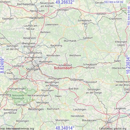
Schorndorf GPS coordinates[2]
48° 48' 19.332" North, 9° 31' 37.956" East
| Map corner | latitude | longitude |
|---|---|---|
| Upper-left | 49.26632°, | 8.82409° |
| Center: | 48.80537°, | 9.52721° |
| Lower-right: | 48.34014°, | 10.23034° |
| Map W x H: | 103×103 km | = 64×64mi |
| max Lat: | 55.01917° ⇑85.3% North |
| Schorndorf: | 48.80537° |
| min Lat: | ⇓14.7% South 47.40724° |
| min Long | Schorndorf | max Long |
| 5.92978° | 9.52721° | 14.98853° |
| W 42.7%⇐ | ⇒57.3% E |
Elevation
Elevation of Schorndorf is 259 m = 850 ft, and this is 9.9 m = 32 ft above average elevation for this country.
| Max E: |
1256 m = 4121 ft | 44.8% |
| Schorndorf | 259 m 850 ft | |
| Avg. | 249.1 m = 817 ft | |
Min E: |
-5 m = -16 ft | 55.2% |
See also: Germany elevation on elevation.city.
Geographical zone
Schorndorf is located in North temperate zone (between Tropic of Cancer and the Arctic Circle). Distance of this North polar circle is 1974.5 km =1226.9 mi to North.| Distance of | km | miles | from Schorndorf |
|---|---|---|---|
| North Pole | 4580.4 | 2846.1 | to North |
| Arctic Circle | 1974.5 | 1226.9 | to North |
| Tropic Cancer | 2820.7 | 1752.7 | to South |
| Equator | 5426.6 | 3371.9 | to South |


Nearby cities:
15 places around Schorndorf: (largest is in red/bold)
• Adelberg
7.2 km =4.5 mi,  131°
131°
• Baltmannsweiler
9.1 km =5.7 mi,  219°
219°
• Birenbach
11.7 km =7.3 mi,  123°
123°
• Börtlingen
9.6 km =6 mi, 126°
• Ebersbach an der Fils
9.9 km =6.2 mi,  181°
181°
• Plüderhausen
5.1 km =3.2 mi,  98°
98°
• Rechberghausen
11.9 km =7.4 mi, 134°
• Reichenbach an der Fils
11.6 km =7.2 mi,  203°
203°
• Rudersberg
8.9 km =5.5 mi,  0°
0°
• Uhingen
12 km =7.5 mi,  159°
159°
• Urbach
3.9 km =2.4 mi,  70°
70°
• Wangen
10.5 km =6.5 mi,  143°
143°
• Weinstadt-Endersbach
12 km =7.5 mi,  274°
274°
• Welzheim
11.2 km =7 mi,  44°
44°
• Winterbach
3.6 km =2.2 mi,  258°
258°
Sources, notices
• [Note1] Compared only with cities in Germany existing in our database
• [Src1] Map data: © OpenStreetMap contributors (CC-BY-SA)
• [Src2] Other city data from geonames.org with taken over terms of usage.
• [Src3] Geographical zone / Annual Mean Temperature by Robert A. Rohde @ Wikipedia
