Plüderhausen geodata
Plüderhausen (Baden-Württemberg) is a seat of a fourth-order administrative division; located in Germany in Europe/Berlin (GMT+2) time zone. With population of 9,559 people, there are 1691 cities with bigger population in this country. Compared to other cities in Germany, 85.4% of cities are located further ↑North; 56.2% of cities are located further →East and 56.7% of cities have lower elevation than Plüderhausen. Note1
Administrative division(s):
- Level 1: Baden-Württemberg
- Level 2: Regierungsbezirk Stuttgart
- Level 3: Rems-Murr-Kreis
- Level 4: Plüderhausen


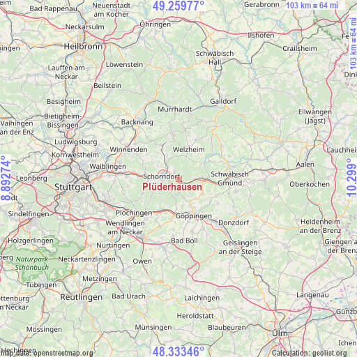
Plüderhausen GPS coordinates[2]
48° 47' 55.5" North, 9° 35' 45.132" East
| Map corner | latitude | longitude |
|---|---|---|
| Upper-left | 49.25977°, | 8.89274° |
| Center: | 48.79875°, | 9.59587° |
| Lower-right: | 48.33346°, | 10.299° |
| Map W x H: | 103×103 km | = 64×64mi |
| max Lat: | 55.01917° ⇑85.4% North |
| Plüderhausen: | 48.79875° |
| min Lat: | ⇓14.6% South 47.40724° |
| min Long | Plüderhausen | max Long |
| 5.92978° | 9.59587° | 14.98853° |
| W 43.8%⇐ | ⇒56.2% E |
Elevation
Elevation of Plüderhausen is 270 m = 886 ft, and this is 20.9 m = 69 ft above average elevation for this country.
| Max E: |
1256 m = 4121 ft | 43.3% |
| Plüderhausen | 270 m 886 ft | |
| Avg. | 249.1 m = 817 ft | |
Min E: |
-5 m = -16 ft | 56.7% |
See also: Germany elevation on elevation.city.
Geographical zone
Plüderhausen is located in North temperate zone (between Tropic of Cancer and the Arctic Circle). Distance of this North polar circle is 1975.3 km =1227.4 mi to North.| Distance of | km | miles | from Plüderhausen |
|---|---|---|---|
| North Pole | 4581.1 | 2846.6 | to North |
| Arctic Circle | 1975.3 | 1227.4 | to North |
| Tropic Cancer | 2820 | 1752.3 | to South |
| Equator | 5425.9 | 3371.5 | to South |


Nearby cities:
15 places around Plüderhausen: (largest is in red/bold)
• Adelberg
4.1 km =2.5 mi,  175°
175°
• Alfdorf
10.3 km =6.4 mi,  60°
60°
• Birenbach
7.5 km =4.7 mi,  140°
140°
• Börtlingen
5.7 km =3.5 mi,  152°
152°
• Ebersbach an der Fils
10.6 km =6.6 mi,  209°
209°
• Lorch
7 km =4.3 mi,  90°
90°
• Rechberghausen
8.3 km =5.2 mi, 154°
• Rudersberg
10.8 km =6.7 mi,  333°
333°
• Schorndorf
5.1 km =3.2 mi,  278°
278°
• Uhingen
10.5 km =6.5 mi, 184°
• Urbach
2.4 km =1.5 mi, 325°
• Wangen
7.8 km =4.8 mi,  171°
171°
• Welzheim
9.1 km =5.7 mi,  17°
17°
• Winterbach
8.5 km =5.3 mi,  270°
270°
• Wäschenbeuren
8 km =5 mi,  122°
122°
Sources, notices
• [Note1] Compared only with cities in Germany existing in our database
• [Src1] Map data: © OpenStreetMap contributors (CC-BY-SA)
• [Src2] Other city data from geonames.org with taken over terms of usage.
• [Src3] Geographical zone / Annual Mean Temperature by Robert A. Rohde @ Wikipedia
