Adelberg geodata
Adelberg (Baden-Württemberg) is a seat of a fourth-order administrative division; located in Germany in Europe/Berlin (GMT+2) time zone. With population of 2,065 people, there are 4976 cities with bigger population in this country. Compared to other cities in Germany, 85.8% of cities are located further ↑North; 56.2% of cities are located further →East and 85.9% of cities have lower elevation than Adelberg. Note1
Administrative division(s):
- Level 1: Baden-Württemberg
- Level 2: Regierungsbezirk Stuttgart
- Level 3: Landkreis Göppingen
- Level 4: Adelberg


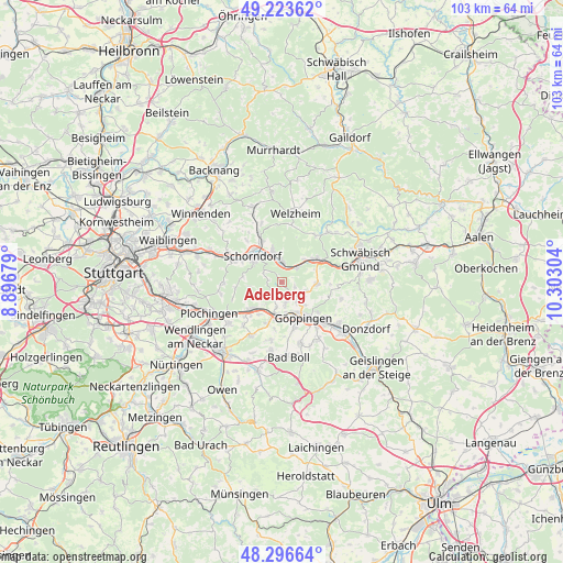
Adelberg GPS coordinates[2]
48° 45' 44.172" North, 9° 35' 59.676" East
| Map corner | latitude | longitude |
|---|---|---|
| Upper-left | 49.22362°, | 8.89679° |
| Center: | 48.76227°, | 9.59991° |
| Lower-right: | 48.29664°, | 10.30304° |
| Map W x H: | 103.1×103.1 km | = 64.1×64.1mi |
| max Lat: | 55.01917° ⇑85.8% North |
| Adelberg: | 48.76227° |
| min Lat: | ⇓14.2% South 47.40724° |
| min Long | Adelberg | max Long |
| 5.92978° | 9.59991° | 14.98853° |
| W 43.8%⇐ | ⇒56.2% E |
Elevation
Elevation of Adelberg is 477 m = 1565 ft, and this is 227.9 m = 748 ft above average elevation for this country.
| Max E: |
1256 m = 4121 ft | 14.1% |
| Adelberg | 477 m 1565 ft | |
| Avg. | 249.1 m = 817 ft | |
Min E: |
-5 m = -16 ft | 85.9% |
See also: Germany elevation on elevation.city.
Geographical zone
Adelberg is located in North temperate zone (between Tropic of Cancer and the Arctic Circle). Distance of this North polar circle is 1979.3 km =1229.9 mi to North.| Distance of | km | miles | from Adelberg |
|---|---|---|---|
| North Pole | 4585.2 | 2849.1 | to North |
| Arctic Circle | 1979.3 | 1229.9 | to North |
| Tropic Cancer | 2815.9 | 1749.7 | to South |
| Equator | 5421.9 | 3369 | to South |


Nearby cities:
15 places around Adelberg: (largest is in red/bold)
• Albershausen
8.3 km =5.2 mi,  198°
198°
• Birenbach
4.8 km =3 mi,  110°
110°
• Börtlingen
2.5 km =1.6 mi, 112°
• Ebersbach an der Fils
7.6 km =4.7 mi,  227°
227°
• Eislingen
10.8 km =6.7 mi,  133°
133°
• Göppingen
7.6 km =4.7 mi,  149°
149°
• Lorch
7.8 km =4.8 mi,  59°
59°
• Plüderhausen
4.1 km =2.5 mi,  355°
355°
• Rechberghausen
4.8 km =3 mi,  137°
137°
• Schorndorf
7.2 km =4.5 mi,  311°
311°
• Uhingen
6.5 km =4 mi,  189°
189°
• Urbach
6.3 km =3.9 mi,  344°
344°
• Wangen
3.8 km =2.4 mi,  166°
166°
• Winterbach
9.8 km =6.1 mi,  294°
294°
• Wäschenbeuren
6.4 km =4 mi,  92°
92°
Sources, notices
• [Note1] Compared only with cities in Germany existing in our database
• [Src1] Map data: © OpenStreetMap contributors (CC-BY-SA)
• [Src2] Other city data from geonames.org with taken over terms of usage.
• [Src3] Geographical zone / Annual Mean Temperature by Robert A. Rohde @ Wikipedia
