Schönwald geodata
Schönwald (Baden-Württemberg) is a populated place; located in Germany in Europe/Berlin (GMT+2) time zone. With population of 2,548 people, there are 4382 cities with bigger population in this country. Compared to other cities in Germany, 94% of cities are located further ↑North; 74% of cities are located further →East and 100% of cities have lower elevation than Schönwald. Note1
Administrative division(s):
- Level 1: Baden-Württemberg
- Level 2: Freiburg Region
- Level 3: Schwarzwald-Baar-Kreis
- Level 4: Schönwald im Schwarzwald


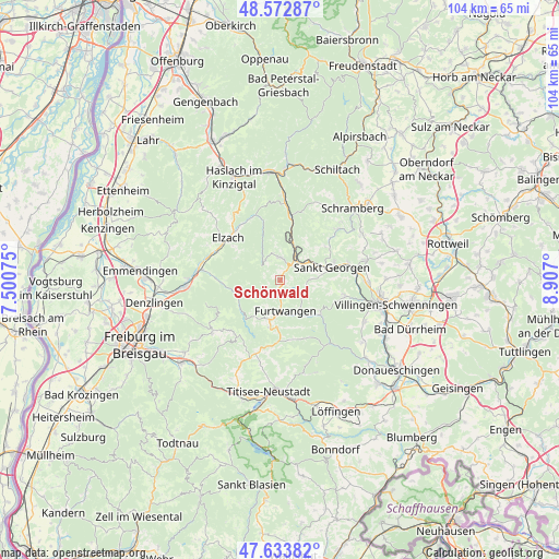
Schönwald GPS coordinates[2]
48° 6' 19.764" North, 8° 12' 13.932" East
| Map corner | latitude | longitude |
|---|---|---|
| Upper-left | 48.57287°, | 7.50075° |
| Center: | 48.10549°, | 8.20387° |
| Lower-right: | 47.63382°, | 8.907° |
| Map W x H: | 104.4×104.4 km | = 64.9×64.9mi |
| max Lat: | 55.01917° ⇑94% North |
| Schönwald: | 48.10549° |
| min Lat: | ⇓6% South 47.40724° |
| min Long | Schönwald | max Long |
| 5.92978° | 8.20387° | 14.98853° |
| W 26%⇐ | ⇒74% E |
Elevation
Elevation of Schönwald is 995 m = 3264 ft, and this is 745.9 m = 2447 ft above average elevation for this country.
| Max E: |
1256 m = 4121 ft | 0% |
| Schönwald | 995 m 3264 ft | |
| Avg. | 249.1 m = 817 ft | |
Min E: |
-5 m = -16 ft | 100% |
See also: Germany elevation on elevation.city.
Geographical zone
Schönwald is located in North temperate zone (between Tropic of Cancer and the Arctic Circle). Distance of this North polar circle is 2052.3 km =1275.2 mi to North.| Distance of | km | miles | from Schönwald |
|---|---|---|---|
| North Pole | 4658.2 | 2894.5 | to North |
| Arctic Circle | 2052.3 | 1275.2 | to North |
| Tropic Cancer | 2742.9 | 1704.4 | to South |
| Equator | 5348.8 | 3323.6 | to South |


Nearby cities:
15 places around Schönwald: (largest is in red/bold)
• Elzach
12.4 km =7.7 mi,  306°
306°
• Furtwangen
6 km =3.7 mi,  177°
177°
• Gutach
15.9 km =9.9 mi,  2°
2°
• Gütenbach
7.4 km =4.6 mi,  212°
212°
• Hornberg
11.9 km =7.4 mi,  10°
10°
• Mönchweiler
16.2 km =10.1 mi,  91°
91°
• Sankt Georgen im Schwarzwald
10 km =6.2 mi,  76°
76°
• Sankt Märgen
13.6 km =8.5 mi,  217°
217°
• Sankt Peter
16.2 km =10.1 mi,  231°
231°
• Schonach im Schwarzwald
4.1 km =2.5 mi,  358°
358°
• St. Peter
16.1 km =10 mi, 232°
• Tennenbronn
14.5 km =9 mi,  49°
49°
• Triberg
3.6 km =2.2 mi,  36°
36°
• Unterkirnach
12.4 km =7.7 mi,  103°
103°
• Vöhrenbach
9.4 km =5.8 mi,  130°
130°
Sources, notices
• [Note1] Compared only with cities in Germany existing in our database
• [Src1] Map data: © OpenStreetMap contributors (CC-BY-SA)
• [Src2] Other city data from geonames.org with taken over terms of usage.
• [Src3] Geographical zone / Annual Mean Temperature by Robert A. Rohde @ Wikipedia
