Tennenbronn geodata
Tennenbronn (Baden-Württemberg) is a populated place; located in Germany in Europe/Berlin (GMT+2) time zone. With population of 3,717 people, there are 3463 cities with bigger population in this country. Compared to other cities in Germany, 92.8% of cities are located further ↑North; 72.4% of cities are located further →East and 97% of cities have lower elevation than Tennenbronn. Note1
Administrative division(s):
- Level 1: Baden-Württemberg
- Level 2: Freiburg Region
- Level 3: Landkreis Rottweil
- Level 4: Schramberg


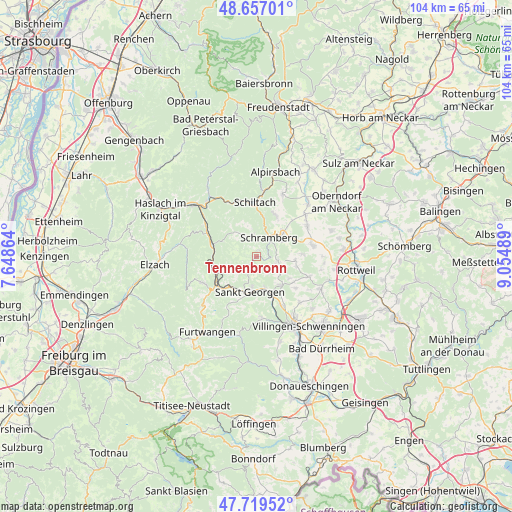
Tennenbronn GPS coordinates[2]
48° 11' 25.476" North, 8° 21' 6.336" East
| Map corner | latitude | longitude |
|---|---|---|
| Upper-left | 48.65701°, | 7.64864° |
| Center: | 48.19041°, | 8.35176° |
| Lower-right: | 47.71952°, | 9.05489° |
| Map W x H: | 104.2×104.2 km | = 64.7×64.7mi |
| max Lat: | 55.01917° ⇑92.8% North |
| Tennenbronn: | 48.19041° |
| min Lat: | ⇓7.2% South 47.40724° |
| min Long | Tennenbronn | max Long |
| 5.92978° | 8.35176° | 14.98853° |
| W 27.6%⇐ | ⇒72.4% E |
Elevation
Elevation of Tennenbronn is 663 m = 2175 ft, and this is 413.9 m = 1358 ft above average elevation for this country.
| Max E: |
1256 m = 4121 ft | 3% |
| Tennenbronn | 663 m 2175 ft | |
| Avg. | 249.1 m = 817 ft | |
Min E: |
-5 m = -16 ft | 97% |
See also: Germany elevation on elevation.city.
Geographical zone
Tennenbronn is located in North temperate zone (between Tropic of Cancer and the Arctic Circle). Distance of this North polar circle is 2042.9 km =1269.4 mi to North.| Distance of | km | miles | from Tennenbronn |
|---|---|---|---|
| North Pole | 4648.8 | 2888.6 | to North |
| Arctic Circle | 2042.9 | 1269.4 | to North |
| Tropic Cancer | 2752.4 | 1710.3 | to South |
| Equator | 5358.3 | 3329.5 | to South |


Nearby cities:
15 places around Tennenbronn: (largest is in red/bold)
• Aichhalden
9.3 km =5.8 mi,  23°
23°
• Dunningen
11.7 km =7.3 mi,  77°
77°
• Gutach
12.1 km =7.5 mi,  302°
302°
• Hardt
4.9 km =3 mi,  99°
99°
• Hornberg
9.1 km =5.7 mi,  284°
284°
• Königsfeld im Schwarzwald
7.7 km =4.8 mi,  139°
139°
• Lauterbach/Schwarzwald
4.5 km =2.8 mi,  351°
351°
• Mönchweiler
11.3 km =7 mi,  152°
152°
• Sankt Georgen im Schwarzwald
7.1 km =4.4 mi,  189°
189°
• Schiltach
11 km =6.8 mi,  356°
356°
• Schonach im Schwarzwald
12.3 km =7.6 mi,  244°
244°
• Schramberg
4.5 km =2.8 mi,  34°
34°
• Seedorf
12.1 km =7.5 mi,  57°
57°
• Triberg
11 km =6.8 mi,  233°
233°
• Unterkirnach
12.4 km =7.7 mi,  175°
175°
Sources, notices
• [Note1] Compared only with cities in Germany existing in our database
• [Src1] Map data: © OpenStreetMap contributors (CC-BY-SA)
• [Src2] Other city data from geonames.org with taken over terms of usage.
• [Src3] Geographical zone / Annual Mean Temperature by Robert A. Rohde @ Wikipedia
