Elzach geodata
Elzach (Baden-Württemberg) is a populated place; located in Germany in Europe/Berlin (GMT+1) time zone. With population of 7,088 people, there are 2161 cities with bigger population in this country. Compared to other cities in Germany, 93% of cities are located further ↑North; 75.9% of cities are located further →East and 69.7% of cities have lower elevation than Elzach. Note1
Administrative division(s):
- Level 1: Baden-Württemberg
- Level 2: Freiburg Region
- Level 3: Landkreis Emmendingen
- Level 4: Elzach


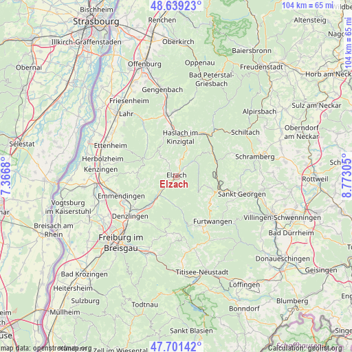
Elzach GPS coordinates[2]
48° 10' 20.892" North, 8° 4' 11.712" East
| Map corner | latitude | longitude |
|---|---|---|
| Upper-left | 48.63923°, | 7.3668° |
| Center: | 48.17247°, | 8.06992° |
| Lower-right: | 47.70142°, | 8.77305° |
| Map W x H: | 104.3×104.3 km | = 64.8×64.8mi |
| max Lat: | 55.01917° ⇑93% North |
| Elzach: | 48.17247° |
| min Lat: | ⇓7% South 47.40724° |
| min Long | Elzach | max Long |
| 5.92978° | 8.06992° | 14.98853° |
| W 24.1%⇐ | ⇒75.9% E |
Elevation
Elevation of Elzach is 356 m = 1168 ft, and this is 106.9 m = 351 ft above average elevation for this country.
| Max E: |
1256 m = 4121 ft | 30.3% |
| Elzach | 356 m 1168 ft | |
| Avg. | 249.1 m = 817 ft | |
Min E: |
-5 m = -16 ft | 69.7% |
See also: Germany elevation on elevation.city.
Geographical zone
Elzach is located in North temperate zone (between Tropic of Cancer and the Arctic Circle). Distance of this North polar circle is 2044.9 km =1270.6 mi to North.| Distance of | km | miles | from Elzach |
|---|---|---|---|
| North Pole | 4650.8 | 2889.9 | to North |
| Arctic Circle | 2044.9 | 1270.6 | to North |
| Tropic Cancer | 2750.4 | 1709 | to South |
| Equator | 5356.3 | 3328.2 | to South |


Nearby cities:
15 places around Elzach: (largest is in red/bold)
• Fischerbach
13.1 km =8.1 mi,  13°
13°
• Gutach
13.6 km =8.5 mi,  51°
51°
• Gutach im Breisgau
8.9 km =5.5 mi,  225°
225°
• Gütenbach
14.9 km =9.3 mi,  156°
156°
• Hausach
14.7 km =9.1 mi,  32°
32°
• Hofstetten
9.6 km =6 mi,  358°
358°
• Hornberg
12.8 km =8 mi,  70°
70°
• Mühlenbach
9.3 km =5.8 mi,  21°
21°
• Schonach im Schwarzwald
10.4 km =6.5 mi,  108°
108°
• Schuttertal
13.7 km =8.5 mi,  319°
319°
• Schönwald
12.4 km =7.7 mi,  126°
126°
• Sexau
14.4 km =8.9 mi,  236°
236°
• Steinach
14.3 km =8.9 mi,  354°
354°
• Triberg
12.9 km =8 mi, 110°
• Waldkirch
11.6 km =7.2 mi,  222°
222°
Sources, notices
• [Note1] Compared only with cities in Germany existing in our database
• [Src1] Map data: © OpenStreetMap contributors (CC-BY-SA)
• [Src2] Other city data from geonames.org with taken over terms of usage.
• [Src3] Geographical zone / Annual Mean Temperature by Robert A. Rohde @ Wikipedia
