Mönchweiler geodata
Mönchweiler (Baden-Württemberg) is a seat of a fourth-order administrative division; located in Germany in Europe/Berlin (GMT+2) time zone. With population of 3,173 people, there are 3853 cities with bigger population in this country. Compared to other cities in Germany, 94% of cities are located further ↑North; 71.8% of cities are located further →East and 99% of cities have lower elevation than Mönchweiler. Note1
Administrative division(s):
- Level 1: Baden-Württemberg
- Level 2: Freiburg Region
- Level 3: Schwarzwald-Baar-Kreis
- Level 4: Mönchweiler


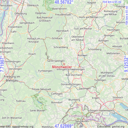
Mönchweiler GPS coordinates[2]
48° 6' 1.44" North, 8° 25' 19.884" East
| Map corner | latitude | longitude |
|---|---|---|
| Upper-left | 48.56782°, | 7.71907° |
| Center: | 48.1004°, | 8.42219° |
| Lower-right: | 47.62869°, | 9.12532° |
| Map W x H: | 104.4×104.4 km | = 64.9×64.9mi |
| max Lat: | 55.01917° ⇑94% North |
| Mönchweiler: | 48.1004° |
| min Lat: | ⇓6% South 47.40724° |
| min Long | Mönchweiler | max Long |
| 5.92978° | 8.42219° | 14.98853° |
| W 28.2%⇐ | ⇒71.8% E |
Elevation
Elevation of Mönchweiler is 783 m = 2569 ft, and this is 533.9 m = 1752 ft above average elevation for this country.
| Max E: |
1256 m = 4121 ft | 1% |
| Mönchweiler | 783 m 2569 ft | |
| Avg. | 249.1 m = 817 ft | |
Min E: |
-5 m = -16 ft | 99% |
See also: Germany elevation on elevation.city.
Geographical zone
Mönchweiler is located in North temperate zone (between Tropic of Cancer and the Arctic Circle). Distance of this North polar circle is 2052.9 km =1275.6 mi to North.| Distance of | km | miles | from Mönchweiler |
|---|---|---|---|
| North Pole | 4658.8 | 2894.8 | to North |
| Arctic Circle | 2052.9 | 1275.6 | to North |
| Tropic Cancer | 2742.3 | 1704 | to South |
| Equator | 5348.3 | 3323.3 | to South |


Nearby cities:
15 places around Mönchweiler: (largest is in red/bold)
• Bad Dürrheim
12 km =7.5 mi,  137°
137°
• Dauchingen
9.6 km =6 mi,  96°
96°
• Deißlingen
13.8 km =8.6 mi,  84°
84°
• Dunningen
13.9 km =8.6 mi,  26°
26°
• Hardt
9.2 km =5.7 mi,  357°
357°
• Königsfeld im Schwarzwald
4.2 km =2.6 mi, 357°
• Niedereschach
9 km =5.6 mi,  66°
66°
• Sankt Georgen im Schwarzwald
7.1 km =4.4 mi,  294°
294°
• Schramberg
14 km =8.7 mi,  348°
348°
• Tennenbronn
11.3 km =7 mi,  332°
332°
• Triberg
14.5 km =9 mi,  283°
283°
• Unterkirnach
4.8 km =3 mi,  240°
240°
• Villingen-Schwenningen
6.8 km =4.2 mi,  128°
128°
• Vöhrenbach
10.7 km =6.6 mi, 238°
• Zimmern ob Rottweil
14.7 km =9.1 mi,  60°
60°
Sources, notices
• [Note1] Compared only with cities in Germany existing in our database
• [Src1] Map data: © OpenStreetMap contributors (CC-BY-SA)
• [Src2] Other city data from geonames.org with taken over terms of usage.
• [Src3] Geographical zone / Annual Mean Temperature by Robert A. Rohde @ Wikipedia
