Unterkirnach geodata
Unterkirnach (Baden-Württemberg) is a seat of a fourth-order administrative division; located in Germany in Europe/Berlin (GMT+2) time zone. With population of 2,895 people, there are 4102 cities with bigger population in this country. Compared to other cities in Germany, 94.3% of cities are located further ↑North; 72.2% of cities are located further →East and 99.2% of cities have lower elevation than Unterkirnach. Note1
Administrative division(s):
- Level 1: Baden-Württemberg
- Level 2: Freiburg Region
- Level 3: Schwarzwald-Baar-Kreis
- Level 4: Unterkirnach


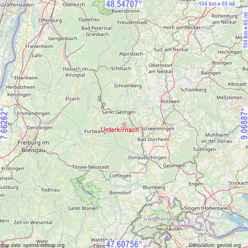
Unterkirnach GPS coordinates[2]
48° 4' 46.056" North, 8° 21' 56.7" East
| Map corner | latitude | longitude |
|---|---|---|
| Upper-left | 48.54707°, | 7.66262° |
| Center: | 48.07946°, | 8.36575° |
| Lower-right: | 47.60756°, | 9.06887° |
| Map W x H: | 104.5×104.5 km | = 64.9×64.9mi |
| max Lat: | 55.01917° ⇑94.3% North |
| Unterkirnach: | 48.07946° |
| min Lat: | ⇓5.7% South 47.40724° |
| min Long | Unterkirnach | max Long |
| 5.92978° | 8.36575° | 14.98853° |
| W 27.8%⇐ | ⇒72.2% E |
Elevation
Elevation of Unterkirnach is 805 m = 2641 ft, and this is 555.9 m = 1824 ft above average elevation for this country.
| Max E: |
1256 m = 4121 ft | 0.8% |
| Unterkirnach | 805 m 2641 ft | |
| Avg. | 249.1 m = 817 ft | |
Min E: |
-5 m = -16 ft | 99.2% |
See also: Germany elevation on elevation.city.
Geographical zone
Unterkirnach is located in North temperate zone (between Tropic of Cancer and the Arctic Circle). Distance of this North polar circle is 2055.2 km =1277 mi to North.| Distance of | km | miles | from Unterkirnach |
|---|---|---|---|
| North Pole | 4661.1 | 2896.3 | to North |
| Arctic Circle | 2055.2 | 1277 | to North |
| Tropic Cancer | 2740 | 1702.6 | to South |
| Equator | 5345.9 | 3321.8 | to South |


Nearby cities:
15 places around Unterkirnach: (largest is in red/bold)
• Bad Dürrheim
13.9 km =8.6 mi,  117°
117°
• Dauchingen
13.7 km =8.5 mi,  85°
85°
• Eisenbach
15 km =9.3 mi,  208°
208°
• Furtwangen
12.2 km =7.6 mi,  255°
255°
• Hardt
12.2 km =7.6 mi,  18°
18°
• Königsfeld im Schwarzwald
7.7 km =4.8 mi,  31°
31°
• Mönchweiler
4.8 km =3 mi,  60°
60°
• Niedereschach
13.8 km =8.6 mi, 64°
• Sankt Georgen im Schwarzwald
5.8 km =3.6 mi,  336°
336°
• Schonach im Schwarzwald
14 km =8.7 mi,  300°
300°
• Schönwald
12.4 km =7.7 mi,  283°
283°
• Tennenbronn
12.4 km =7.7 mi,  355°
355°
• Triberg
11.4 km =7.1 mi, 300°
• Villingen-Schwenningen
9.7 km =6 mi,  101°
101°
• Vöhrenbach
5.9 km =3.7 mi,  236°
236°
Sources, notices
• [Note1] Compared only with cities in Germany existing in our database
• [Src1] Map data: © OpenStreetMap contributors (CC-BY-SA)
• [Src2] Other city data from geonames.org with taken over terms of usage.
• [Src3] Geographical zone / Annual Mean Temperature by Robert A. Rohde @ Wikipedia
