Schönsee geodata
Schönsee (Bavaria) is a populated place; located in Germany in Europe/Berlin (GMT+2) time zone. With population of 2,720 people, there are 4215 cities with bigger population in this country. Compared to other cities in Germany, 75.5% of cities are located further ↑North; 88.3% of cities are located further ←West and 96.8% of cities have lower elevation than Schönsee. Note1
Administrative division(s):
- Level 1: Bavaria
- Level 2: Upper Palatinate
- Level 3: Landkreis Schwandorf
- Level 4: Schönsee


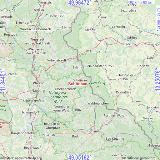
Schönsee GPS coordinates[2]
49° 30' 37.08" North, 12° 32' 51.468" East
| Map corner | latitude | longitude |
|---|---|---|
| Upper-left | 49.96472°, | 11.84451° |
| Center: | 49.5103°, | 12.54763° |
| Lower-right: | 49.05162°, | 13.25076° |
| Map W x H: | 101.5×101.5 km | = 63.1×63.1mi |
| max Lat: | 55.01917° ⇑75.5% North |
| Schönsee: | 49.5103° |
| min Lat: | ⇓24.5% South 47.40724° |
| min Long | Schönsee | max Long |
| 5.92978° | 12.54763° | 14.98853° |
| W 88.3%⇐ | ⇒11.7% E |
Elevation
Elevation of Schönsee is 653 m = 2142 ft, and this is 403.9 m = 1325 ft above average elevation for this country.
| Max E: |
1256 m = 4121 ft | 3.2% |
| Schönsee | 653 m 2142 ft | |
| Avg. | 249.1 m = 817 ft | |
Min E: |
-5 m = -16 ft | 96.8% |
See also: Germany elevation on elevation.city.
Geographical zone
Schönsee is located in North temperate zone (between Tropic of Cancer and the Arctic Circle). Distance of this North polar circle is 1896.1 km =1178.2 mi to North.| Distance of | km | miles | from Schönsee |
|---|---|---|---|
| North Pole | 4502 | 2797.4 | to North |
| Arctic Circle | 1896.1 | 1178.2 | to North |
| Tropic Cancer | 2899.1 | 1801.4 | to South |
| Equator | 5505 | 3420.6 | to South |


Nearby cities:
15 places around Schönsee: (largest is in red/bold)
• Dieterskirchen
14.1 km =8.8 mi,  222°
222°
• Eslarn
8.3 km =5.2 mi,  346°
346°
• Gleiritsch
16.8 km =10.4 mi,  265°
265°
• Moosbach
13.2 km =8.2 mi,  311°
311°
• Niedermurach
14.1 km =8.8 mi,  241°
241°
• Oberviechtach
11.1 km =6.9 mi, 238°
• Stadlern
4.7 km =2.9 mi,  95°
95°
• Teunz
12.2 km =7.6 mi,  255°
255°
• Thanstein
15.3 km =9.5 mi,  202°
202°
• Tiefenbach
8.9 km =5.5 mi,  163°
163°
• Treffelstein
10.9 km =6.8 mi,  153°
153°
• Tännesberg
16.1 km =10 mi,  278°
278°
• Waidhaus
15.1 km =9.4 mi, 345°
• Weiding
3.3 km =2.1 mi, 155°
• Winklarn
10.5 km =6.5 mi,  207°
207°
Sources, notices
• [Note1] Compared only with cities in Germany existing in our database
• [Src1] Map data: © OpenStreetMap contributors (CC-BY-SA)
• [Src2] Other city data from geonames.org with taken over terms of usage.
• [Src3] Geographical zone / Annual Mean Temperature by Robert A. Rohde @ Wikipedia
