Waidhaus geodata
Waidhaus (Bavaria) is a populated place; located in Germany in Europe/Berlin (GMT+2) time zone. With population of 2,467 people, there are 4477 cities with bigger population in this country. Compared to other cities in Germany, 72.7% of cities are located further ↑North; 87.9% of cities are located further ←West and 90.9% of cities have lower elevation than Waidhaus. Note1
Administrative division(s):
- Level 1: Bavaria
- Level 2: Upper Palatinate
- Level 3: Landkreis Neustadt an der Waldnaab
- Level 4: Waidhaus, Markt


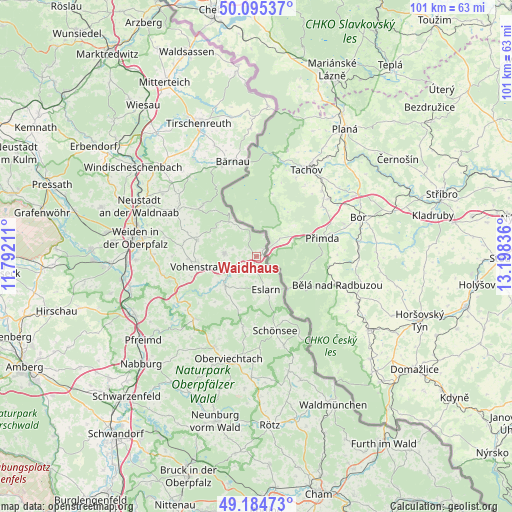
Waidhaus GPS coordinates[2]
49° 38' 31.848" North, 12° 29' 42.828" East
| Map corner | latitude | longitude |
|---|---|---|
| Upper-left | 50.09537°, | 11.79211° |
| Center: | 49.64218°, | 12.49523° |
| Lower-right: | 49.18473°, | 13.19836° |
| Map W x H: | 101.3×101.3 km | = 62.9×62.9mi |
| max Lat: | 55.01917° ⇑72.7% North |
| Waidhaus: | 49.64218° |
| min Lat: | ⇓27.3% South 47.40724° |
| min Long | Waidhaus | max Long |
| 5.92978° | 12.49523° | 14.98853° |
| W 87.9%⇐ | ⇒12.1% E |
Elevation
Elevation of Waidhaus is 526 m = 1726 ft, and this is 276.9 m = 908 ft above average elevation for this country.
| Max E: |
1256 m = 4121 ft | 9.1% |
| Waidhaus | 526 m 1726 ft | |
| Avg. | 249.1 m = 817 ft | |
Min E: |
-5 m = -16 ft | 90.9% |
See also: Germany elevation on elevation.city.
Geographical zone
Waidhaus is located in North temperate zone (between Tropic of Cancer and the Arctic Circle). Distance of this North polar circle is 1881.5 km =1169.1 mi to North.| Distance of | km | miles | from Waidhaus |
|---|---|---|---|
| North Pole | 4487.4 | 2788.3 | to North |
| Arctic Circle | 1881.5 | 1169.1 | to North |
| Tropic Cancer | 2913.8 | 1810.6 | to South |
| Equator | 5519.7 | 3429.8 | to South |


Nearby cities:
15 places around Waidhaus: (largest is in red/bold)
• Bärnau
19.3 km =12 mi,  346°
346°
• Eslarn
6.8 km =4.2 mi,  163°
163°
• Flossenbürg
14.6 km =9.1 mi,  314°
314°
• Floß
18.2 km =11.3 mi,  299°
299°
• Georgenberg
8.6 km =5.3 mi,  321°
321°
• Konradsreuth
18.1 km =11.2 mi, 307°
• Leuchtenberg
17.8 km =11.1 mi,  253°
253°
• Moosbach
8.5 km =5.3 mi,  226°
226°
• Pleystein
6.4 km =4 mi,  276°
276°
• Schönsee
15.1 km =9.4 mi,  165°
165°
• Stadlern
17.3 km =10.7 mi,  150°
150°
• Tännesberg
17.2 km =10.7 mi,  224°
224°
• Vohenstrauß
11.5 km =7.1 mi,  259°
259°
• Waldthurn
12.4 km =7.7 mi,  285°
285°
• Weiding
18.4 km =11.4 mi, 163°
Sources, notices
• [Note1] Compared only with cities in Germany existing in our database
• [Src1] Map data: © OpenStreetMap contributors (CC-BY-SA)
• [Src2] Other city data from geonames.org with taken over terms of usage.
• [Src3] Geographical zone / Annual Mean Temperature by Robert A. Rohde @ Wikipedia
