Eslarn geodata
Eslarn (Bavaria) is a populated place; located in Germany in Europe/Berlin (GMT+2) time zone. With population of 3,117 people, there are 3902 cities with bigger population in this country. Compared to other cities in Germany, 74.1% of cities are located further ↑North; 88.1% of cities are located further ←West and 90% of cities have lower elevation than Eslarn. Note1
Administrative division(s):
- Level 1: Bavaria
- Level 2: Upper Palatinate
- Level 3: Landkreis Neustadt an der Waldnaab
- Level 4: Eslarn, Markt


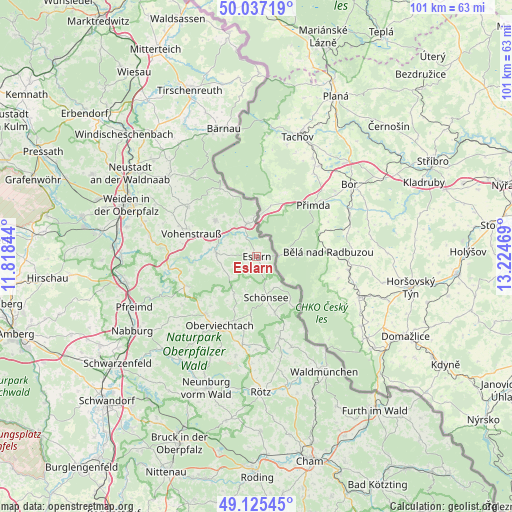
Eslarn GPS coordinates[2]
49° 35' 0.42" North, 12° 31' 17.616" East
| Map corner | latitude | longitude |
|---|---|---|
| Upper-left | 50.03719°, | 11.81844° |
| Center: | 49.58345°, | 12.52156° |
| Lower-right: | 49.12545°, | 13.22469° |
| Map W x H: | 101.4×101.4 km | = 63×63mi |
| max Lat: | 55.01917° ⇑74.1% North |
| Eslarn: | 49.58345° |
| min Lat: | ⇓25.9% South 47.40724° |
| min Long | Eslarn | max Long |
| 5.92978° | 12.52156° | 14.98853° |
| W 88.1%⇐ | ⇒11.9% E |
Elevation
Elevation of Eslarn is 514 m = 1686 ft, and this is 264.9 m = 869 ft above average elevation for this country.
| Max E: |
1256 m = 4121 ft | 10% |
| Eslarn | 514 m 1686 ft | |
| Avg. | 249.1 m = 817 ft | |
Min E: |
-5 m = -16 ft | 90% |
See also: Germany elevation on elevation.city.
Geographical zone
Eslarn is located in North temperate zone (between Tropic of Cancer and the Arctic Circle). Distance of this North polar circle is 1888 km =1173.1 mi to North.| Distance of | km | miles | from Eslarn |
|---|---|---|---|
| North Pole | 4493.9 | 2792.4 | to North |
| Arctic Circle | 1888 | 1173.1 | to North |
| Tropic Cancer | 2907.2 | 1806.4 | to South |
| Equator | 5513.2 | 3425.7 | to South |


Nearby cities:
15 places around Eslarn: (largest is in red/bold)
• Georgenberg
15.1 km =9.4 mi,  331°
331°
• Gleiritsch
17.7 km =11 mi,  237°
237°
• Moosbach
8 km =5 mi,  274°
274°
• Oberviechtach
15.9 km =9.9 mi,  208°
208°
• Pleystein
11.1 km =6.9 mi,  311°
311°
• Schönsee
8.3 km =5.2 mi,  166°
166°
• Stadlern
10.8 km =6.7 mi,  142°
142°
• Teunz
14.9 km =9.3 mi,  221°
221°
• Tiefenbach
17.3 km =10.7 mi, 165°
• Tännesberg
15.1 km =9.4 mi,  247°
247°
• Vohenstrauß
14 km =8.7 mi,  288°
288°
• Waidhaus
6.8 km =4.2 mi,  343°
343°
• Waldthurn
17 km =10.6 mi, 305°
• Weiding
11.6 km =7.2 mi,  163°
163°
• Winklarn
17.7 km =11 mi,  189°
189°
Sources, notices
• [Note1] Compared only with cities in Germany existing in our database
• [Src1] Map data: © OpenStreetMap contributors (CC-BY-SA)
• [Src2] Other city data from geonames.org with taken over terms of usage.
• [Src3] Geographical zone / Annual Mean Temperature by Robert A. Rohde @ Wikipedia
